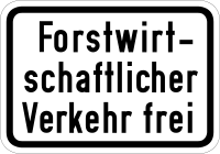
Tag:access=forestry
| Description |
|---|
| Value that restricts access to the road to usage for forestry purposes (not restricted to a technical class of vehicles). |
| Group: restrictions |
| Used on these elements |
| See also |
| Status: approved |
| Tools for this tag |
|
Access values are used to describe the legal access for various facilities.
This *=forestry value applies to objects for which entrance or usage is explicitly restricted to forestry purposes only. This is valid for any type of access, not limited to the technical class of forestry motor vehicles; e.g. tractors (for the technical class please use the key forestry=*).
Note that the specific tag access=forestry applies also to pedestrians unless overridden with foot=yes - in typical real world cases using vehicle=forestry or motor_vehicle=forestry (when cyclists are allowed in general) might be more suited.
access=forestry (as a value) was proposed together with similar concept of access=agricultural, distinguishing between forestry and agricultural current usage of the road ("a type of traffic"), both "not depending on the type of transport (tractors but also motorcars, bicycles, mopeds are allowed if they are there for agricultural purposes)"[1].
Traffic signs allowing forestry usage are sometimes combined with agricultural usage; see motor_vehicle=agricultural;forestry.
For more details, examples and possible tagging mistakes please see access=agricultural.
See also
- access=agricultural – for the similar concept for agricultural usage of the road
- forestry=* – for legal access for the technical class of forestry vehicles
- motor_vehicle=forestry (used approx. 74k times per 2021-08-31; Taginfo)
- vehicle=forestry (used approx. 14k times per 2021-08-31; Taginfo)
