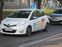
Tag:amenity=driving_school
Jump to navigation
Jump to search
| Description |
|---|
| A school to learn to drive a motor vehicle. |
| Rendering in OSM Carto |
| Group: education |
| Used on these elements |
| Useful combination |
|
| See also |
| Status: de facto |
| Tools for this tag |
|
This tag is used for schools that offer theoretical and/or practical motor vehicle driving lessons. See Driver's education on Wikipedia.
The current tag usage suggests that users focus on the indoor facilities of a driving school, comprising e.g. an office, a seminar room for theoretical lessons, and a stationary driving simulator.
How to map
Set a node at the center of the feature or draw an area along its outline.
Additional tags
- name=*
- license_classes=A1;A;B;BE;C -
![Wikipedia [W]](/w/images/2/24/Wikipedia-16px.png) Classes of driver's licenses
Classes of driver's licenses - operator=*
- Addresses
- phone=*
- website=*
- wheelchair=*
See also
- For outdoor facilities, used for driving lessons, driver safety training, or skid training on a closed course, amenity=driver_training has been proposed. Currently maneuvering area could be tagged as:
highway=service
service=driving_learning
or
highway=service
service=driving_exercise
Other most frequently used ways of marking the maneuvering area together with the number of occurrences:
| Tag | Count |
|---|---|
| service=driving_learning | |
| service=driving_exercise | |
| service=driving_alley | |
| service=driving_training | |
| service=driving_aisle |
