Tag:barrier=retaining_wall
 |
| Description |
|---|
| A structure that holds back soil or rock from a building, structure or area. |
| Rendering in OSM Carto |

|
| Group: barriers |
| Used on these elements |
| Useful combination |
| Status: approved |
| Tools for this tag |
|
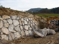
A ![]() retaining wall is a structure that holds back soil or rock from a building, structure or area. Retaining walls prevent downslope movement or erosion and provide support for vertical or near-vertical grade changes.
retaining wall is a structure that holds back soil or rock from a building, structure or area. Retaining walls prevent downslope movement or erosion and provide support for vertical or near-vertical grade changes.
Also consider man_made=embankment for a raised bank to carry a road, railway, or the like.
Also consider one-sided cutting=*s if it lines a highway and isn't a man-made wall. They're more flexible (but slightly less accurate) if you're refining an established way which already has other aspects that rely on its direction, such as already being oneway=yes or cycleway:left=lane, that would need to change to incorporate barrier=retaining_wall's "right side is bottom, left side is top" convention.
How to map

barrier=retaining_wall behaves same as natural=cliff, that is no crossing as left-right are different heights.
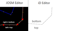
Lower side on right side of way direction, often rendered with dots, triangles or the like.
Renderers and editors might indicate the lower side of the retaining wall (the right side of the OSM way) with small triangles pointing downwards.
Other tags commonly used with barrier=retaining_wall:
Example

47°48′45.36″ N, 8°10′44.47″ E
Browse object 413183895![]() 413183895 on map.
413183895 on map.