Tag:building=terrace
| Description |
|---|
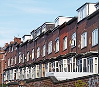
| The outline of a linear row of residential dwellings, each of which normally has its own entrance, which form a terrace ("row-house" or "townhouse" in North American English). |
| Rendering in OSM Carto |

|
| Group: buildings |
| Used on these elements |
| See also |
| Status: de facto |
| Tools for this tag |
|
This tag is most commonly used as a less-detailed option to define the outline of a linear row of residential dwellings which form a ![]() terrace. Each of the dwellings normally has its own entrance. These are known as "rowhouse" or "townhouse" in North American English.
terrace. Each of the dwellings normally has its own entrance. These are known as "rowhouse" or "townhouse" in North American English.
How to map
Draw a single ![]() area along the outline of the whole terrace. Optionally add entrance=* for each entrance.
area along the outline of the whole terrace. Optionally add entrance=* for each entrance.
- This tag is not meant to be used for a platform that extends outwards from a building.
Alternative methods
As often in OSM there are multiple correct ways to map a given situation.
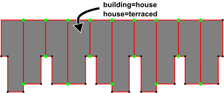
A preferred approach is to map each dwelling separately using building=house, but keeping at least two nodes in common for adjoining houses. This is more appropriate for cases where it is clearly several independent buildings that happen to share walls, but may have been built at different times, by different builders, with different styles, etc, and where each building is maintained separately from the others. When using this method house=terraced can be put on the individual units.
Deprecated methods
A third (not recommended) approach is to tag the outline of the entire physical structure with building=terrace, and inside the outline, draw the borders of each individual dwelling and tag it with building:part=house. This is no longer recommended, as building:part=* should not be used to represent a separately addressable building (addr:unit=* is an exception to this) .

