Tag:information=tactile_model
Jump to navigation
Jump to search
| Description |
|---|
| A model of buildings and surroundings that can be explored with fingers. |
| Group: tourism |
| Used on these elements |
| Requires |
| Status: in use |
| Tools for this tag |
|
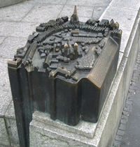
A tactile model is a model of buildings and surroundings that can be explored with fingers.
How to map
Add a node ![]() where the tactile model is located, and add tourism=information + information=tactile_model.
where the tactile model is located, and add tourism=information + information=tactile_model.
Tags used in combination
- blind:description:en=Tactile model showing the historic capitol.
- blind:description:de=Taktiles Modell vom historischen Rathaus.
- tactile_writing=*
- scale=1:1000
- braille=yes/no (If you know the language you can also use braille:XX=yes/no )
- embossed_letters=yes/no if there are embossed printed letters (If you know the language you can also use embossed_letters:XX=yes/no )
- artist=* Name of artist who created the model.
- material=* e.g. steel, bronze, plastic.
- website=* if there is a website with additional information
- represented_date=* The year in which the model was created if representing the current reality. The year represented if the model is historical.
Examples
This is a picture of a public tactile model in Braunschweig, Germany, at the market place Altstadtmarkt.
Tactile model in Soest, Germany.
Tactile model in Münster, Germany.
Tactile model with Braille text in Bielefeld, Germany.
Tactile model with Braille text in Tübingen, Germany.
Rendering of public tactile models on visual maps
There is a visual map with features for the blind:
Tactile models are planned to be rendered there
List of tactile models (and maps)
Germany
Todo
List of tactile models and maps to work on tactile_map/list
See also
- DisabilityDescription
- tactile maps
- OSM for the blind
- tactile_paving=*
- Tastbare Sehenswürdigkeiten auf barrierefreier-tourismus.info


