Tag:landuse=brownfield
| Description |
|---|
| Land which was developed which is no longer in use. |
| Rendering in OSM Carto |

|
| Group: lifecycle |
| Used on these elements |
| See also |
| Status: de facto |
| Tools for this tag |
|
Brownfield is a land which was previously developed which is not currently in use. Brownfield land may be vacant or scheduled for future development.
How to map
Brownfields are mapped as areas, as they represent a form of land use in the same sense as areas mapped with the tag landuse=*. Brownfield is a description which applies to many situations which can look quite different from each other on the ground, as it describes a state, and not necessarily a land cover. Brownfield land use could be mapped at vacant sites where buildings have been demolished, sites that have decaying structures which are in an indefinite state of disuse, or sites that are in an interim phase where their former use is no longer applicable and construction has not started for a planned use. The common factors in all brownfields are that they were used by people at some point, and that they are not currently used.
It might make sense to use multipolygons to map brownfields, for example if a large brownfield area has roads and paths through it which are still in use, it makes sense to draw the brownfield as separate from those features. The public right of way on an operational street does not necessarily become a brownfield just because it is surrounded by brownfield land. Multipolygons can also be used to apply differing descriptive tags to different portions of a brownfield, for example, if a natural=* overgrowth has developed within part of it. Brownfield areas that have resulted from the demolition of multiple directly adjacent buildings are typically mapped as contiguous areas rather than as separate parcels where properties once were. If a block of houses is razed, the features of that block, including where properties began and ended, ceased to be visible on the ground. It is not technically necessary to leave address nodes in place of demolished buildings, but leaving addresses with a demolished:building tag may be helpful to other editors for recent demolitions, and prevent the re-mapping of the original buildings based on out of date imagery. Some editor discretion may be necessary to determine whether or not address nodes should remain; as time progresses it may have less relevance to the site and lead to more confusion.
Useful tags to use in combination
- start_date=*, to describe when the land became a brownfield. This could be a demolition date for vacant sites.
- was:landuse=*, to describe the former use of a brownfield. For example,
was:landuse=residential. - plant_community=*, to describe vegetation which has proliferated on brownfield land. Plant communities which re-colonize brownfields are often described as (en), so
plant_community=ruderalmay be an appropriate way to describe the vegetation. Brownfields often do not start to resemble the native vegetation surrounding them until quite a while after their abandonment, when those native plants have gradually out-competed the ruderal ones. - landcover=*, a proposed and in use way to describe the cover of a landuse feature. This tag lacks support from popular renderers and editors, as tagging land cover as "landuse" is still common, but that should not necessarily be a justification in itself not to use it.
- owner=*, while OSM is not a land registry and the specific details of cadastral data extend beyond its scope, it may be useful to indicate who is responsible for an area of brownfield land. For example, municipal authorities will often acquire residential areas prior to demolition, and retain ownership afterwards.
Identification
Bear in mind that it is not always easy to tell if a site is a brownfield or not. Some former brownfields have taken on some kind of community use or undergone a remediation process, making landuse=allotments a more appropriate land use classification than brownfield. Buildings and structures that look to be in a state of decay may in fact still be in use. Further, recently condemned brownfield land might not be visible in aerial imagery. This is a feature for which ground surveys are particularly helpful. Knowing the context around how and why certain sites may become brownfields can help in making inferences about how to map them. For example, in cities where many former residential blocks are demolished after an extended state of vacancy and disrepair, you may notice patterns in what demolished blocks tend to look like, what structures tend to get left behind if any, and where these demolitions are likely to occur.
Rendering in OSM Carto
Example
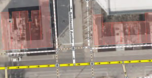
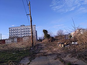
These images and examples are from a cluster of adjacent brownfields in the Johnston Square![]() Johnston Square area of Baltimore, Maryland, United States. This area features some different features which you may encounter at brownfield sites. Johnston Square is a predominantly residential area that has a commercial corridor running through it, and some industrial activity around the periphery. It has changed quite dramatically over a short period of time as abandoned structures have been demolished, and new structures are in the process of construction or are being planned in some places while in others the land remains dormant.
Johnston Square area of Baltimore, Maryland, United States. This area features some different features which you may encounter at brownfield sites. Johnston Square is a predominantly residential area that has a commercial corridor running through it, and some industrial activity around the periphery. It has changed quite dramatically over a short period of time as abandoned structures have been demolished, and new structures are in the process of construction or are being planned in some places while in others the land remains dormant.
| Photograph | Description | Map example |
|---|---|---|
| The terraced houses on this block have deteriorated to a degree where you can see through them to the other side. While vacancy on it's own is not enough to deem a site a brownfield, it is clear here that this block is no longer suited for residential use without substantial construction. It makes sense to be careful about what you are basing your assessment of land use on - it may not be obvious if a block still has residents or not. Only map brownfields if you are sure that is what they are. If a single house is surrounded by vacant land, do not include that in the brownfield polygon if you draw one surrounding it. | 
| |
| Obstructions to the pedestrian right of way along sidewalks and paths are common around brownfield sites. This picture shows an example of stabilizing support beams keeping a decaying house in place at an intersection have made the sidewalk impassable. Other common obstructions include an accumulation of litter, overgrown vegetation, utility vehicles, or even abandoned/unattended vehicles. Sidewalks may also be in a state of decay themselves. Mapping of barrier shown in context in iD screenshot to the right. |

| |
| The roadway along this block remains in tact and connected to the surrounding road network, but all the houses which used to stand along it have been demolished. For a period of time this site was leased to a community organization to operate an urban farm, but has since become disused again. The vegetation overgrowth you can see developing here consists of short-statured plants which could be mapped as natural=scrub. Easternmost block in image to the right, shown in context. |

|
See also
- Proposed features/Wasteland - similar/overlapping proposal
- Land use and areas of natural land - general information of landuse tagging
- landuse=greenfield
- landuse=construction
External links
- Brownfield land on Wikipedia


