Tag:leisure=horse_riding
| Description |
|---|
| A facility where people practise horse riding, usually in their spare time, e.g. a riding centre. For a riding arena use leisure=pitch + sport=equestrian. |
| Group: leisure |
| Used on these elements |
| Useful combination |
| See also |
| Status: de facto |
| Tools for this tag |
|
|
For a |
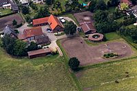
The tag leisure=horse_riding is used to tag an ![]() equestrian facility, often called equestrian centre, riding centre or riding stables, where people practise horse riding, typically in their spare time.
The tag is for the whole area which may contain one or more riding arenas, stables, riding halls, other related buildings or paddocks (compare also Riding).
equestrian facility, often called equestrian centre, riding centre or riding stables, where people practise horse riding, typically in their spare time.
The tag is for the whole area which may contain one or more riding arenas, stables, riding halls, other related buildings or paddocks (compare also Riding).
How to map
Map the facility either as an area ![]() or as a node
or as a node ![]() , but ideally as an area if the perimeter is known. Tag it with leisure=horse_riding. Usually at least a name=* is also added.
, but ideally as an area if the perimeter is known. Tag it with leisure=horse_riding. Usually at least a name=* is also added.
When not to use
Use this tag only once for the whole facility, don't use it multiple times on different objects belonging to it (one feature, one OSM element rule; but sport=equestrian can be used multiple times within the facility). It's also not intended for racecourses (compare Riding and horse_racing).
Examples

See also
- amenity=animal_boarding + animal_boarding=horse -
 livery yard
 - amenity=animal_breeding + animal_breeding=horse -
 stud farm
 - building=stable -
 stable
 - building=riding_hall -
 riding hall
 - landuse=animal_keeping - area of land that is used to keep animals
- landuse=farmyard - area of land with farm buildings
- landuse=recreation_ground - green space for general recreation
- leisure=pitch + sport=equestrian -
 riding arena
 - leisure=track + sport=equestrian - gallop track
- leisure=stadium
- leisure=sports_centre
- place=* - named place
- sport=horse_racing -
 horse racing
 - tourism=trail_riding_station
