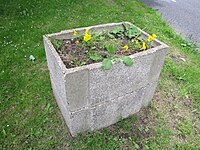
Tag:man_made=planter
| Description |
|---|
| A raised structure for planting flowers or other ornamental plants. |
| Group: man made |
| Used on these elements |
| Useful combination |
| See also |
| Status: in use |
| Tools for this tag |
|
Planters are common features of urban landscaping, containing soil and planted with flowers, ornamental shrubs or small trees. They may be heavy containers made from concrete or other materials or built into other landscape features. In many cases they are a decorative way of creating obstacles, for instance as a barrier of some kind.
They form some sort of raised bed for plants to be put in. This is in contrast to landuse=flowerbed which is typically at ground level.
In some cases, historic objects (such as water troughs for horses) are reused as planters (see examples below).
How to map
Add a node ![]() at the centre or draw the outline
at the centre or draw the outline ![]() of the planter and tag the node or area with man_made=planter.
of the planter and tag the node or area with man_made=planter.
Do not use for smaller flower-pots which can be lifted by a single person, or for window boxes or similar containers which are also used for plants.
Tags used in combination
- material=* – The material the border of the planter is made of.
- surface=* – The surface of the top level of filling in the planter (below any plants).
- barrier=planter – If the planter also acts as a barrier for traffic, consider adding.


