Tag:place=farm
Jump to navigation
Jump to search
| Description |
|---|
| An individually named farm. |
| Group: places |
| Used on these elements |
| Useful combination |
|
| See also |
| Status: in use |
| Tools for this tag |
|
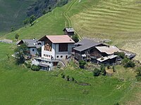
place=farm is used to map an individually named farm, often including an area where a family of farmers resides.
A farm can be a part of a human settlement (place=* like hamlet, village, town) which has buildings and land for farming. Usually there are a few central buildings around a landuse=farmyard with landuse=farmland or landuse=meadow surrounding it.
If the farm is not part of a bigger settlement (regarding structure not administration) and the farm and comprising settlement itself is not bigger than defined for isolated dwellings in your country, use place=isolated_dwelling.
