Tagging illustrated
An illustrated guide to tagging for typical roads. This is a draft. Edits, comments and changes are encouraged and welcome.
Divided highway
A typical divided highway. This one shows two travel lanes in each direction, with a concrete dividing barrier, and hard shoulders.
Juction Illustration: Divided highway & Arterial road
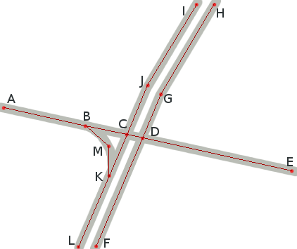
Typical divided highway junction with an arterial road at a traffic signal. In this case only one of the four right turns has a slip lane (a dedicated turning lane) (EB to SB). Any left turn at this intersection uses the left-turn lanes.
Nodes C and D are each tagged highway=traffic_signals. Nodes B and K are each tagged highway=motorway_junction.
The West-East arterial road is one lane each way.
Way A,B,C,D,E is tagged highway=secondary, name=Fisher Mills Road, reg_name=Waterloo regional road 38.
The North-South divided highway is two-lanes each way, with a central barrier.
The Northbound way is tagged highway=primary, oneway=yes, lanes=2, name=Hespeler Road, reg_name=Hwy 24 and has nodes ordered F,D,G,H.
The Southbound way is tagged highway=primary, oneway=yes, lanes=2, name=Hespeler Road, reg_name=Hwy 24 and has nodes ordered I,J,C,K,L.
The slip lane is tagged highway=primary_link, oneway=yes, lanes=1, name=ramp to Hespeler Road Southbound and has nodes ordered B,M,K.
Referenced tags
- Tag:highway=motorway_junction
- Tag:highway=secondary, Tag:highway=primary
- Tag:highway=traffic_signals
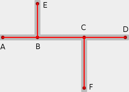
These two roads meet at an offset junction.
The road segment B-C is signposted with the names of both roads. What is the correct method for tagging the segments (deprecated) and ways for this type of junction?


