Tijuana Building Footprints Import Project
About
This page proposes a partial semi-automatic import of building footprints and building levels, heights and type of buildings from public data property of the City of Tijuana, that is compatible with the ODbL in accordance with article 2 of the Law on Transparency and Access to Public Information for the State of Baja California.
Import Plan Outline
- Incorporate land use from layer containing current land use.
- Preprocess attributes to conform the OSM tag requierements.
- Download current OSM buildings to make a spatial selection to remove from the import existing buildging in the OSM database.
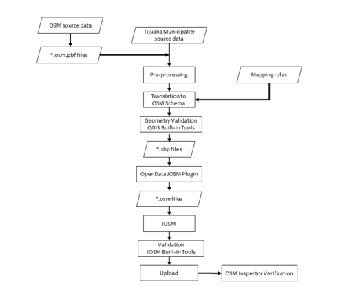
- Perform geometry check and validation with QGIS.
- Check and fix invalid data with JOSM validator.
- Perform the import with JOSM.
- Fix validation errors using the OSM Inspector web app.
- Manually inspect the imported data to remove any non existing buildings misintrerpreted by the machine learning algorithm.
Goals
To provide existing public data about OSM buildings for the city of Tijuana, Baja California, Mexico with open data made available by law. To benefit the Mexican OSM community with data that would take a lot of time and effort to generate manually.
Schedule
Data preparation - Q1, 2022
Bulk import - Q2, 2022
Fix validation errors - Q2, 2022
Manually inspect existing buildings - Q3 2022 and onwards
Import Data
Background
Data sources
Edificaciones 2015
Uso Actual del Suelo 2022
Data license
See article 2 of the corresponding law [1] for the original open data license.
Type of license: Public domain government data
Link to permission (if required): Not required
OSM attribution (if required): Ayuntamiento de Tijuana (City of Tijuana)
ODbL Compliance verified: Yes
OSM Data Files
The OSM data files will be uploaded to the following link OSM Files.
Import Type
This will be a one-time import using a combination of methods and tools:
An automated process for converting and pre-processing the data. An automated process to avoid conflating the data with the existing OSM data and outputting OSM change files. Manual checking, uploading and validation of the resulting OSM change files using the OSM Inspector, via web app. Data Preparation Data Reduction & Simplification Conversion and translation The source data is in Shapefile format and contains attributes that need to be translated to OSM tags. The attribute mapping is described in detail in the next section. These are the attributes present in the Ayuntamiento de Tijuana source data
Tagging Plans
EDIFICACIONES 2015 ATTRIBUTE TO OSM MAPPING
| Field (SP) | Field (English) | Description (SP) | Description (EN) | OSM Tag |
| usossuelo | Land Use | Clasificación de uso de suelo | Land Use Classification | building=value |
| altura | Height | Altura del edificio en metros | Height of the building in meters | height=<number> |
| niveles | Levels | Niveles del edificio | The number of visible levels | building:levels=<number> |
Changeset Tags
The changesets generated will be tagged with source=Ayuntamiento de Tijuana.
Data Transformation
The current version of QGIS (3.22.4) allows the user to directly import vector data coming from “.osm” files, this option simplified the preprocessing tasks by using the built-in geoprocessing vector tools of QGIS.
Once the data was cleaned to avoid overwriting existing buildings, overlayed features and duplicated nodes, the layer was saved as shapefile (.shp).
Using the JOSM plugin called OpenData allowed us to import shapefiles and convert them into “.osm” extensions.
It is well known that working with files with a considerable number of polygons on JOSM is usually a trouble, to avoid this problem the original layer was divided into six sections with no specific criteria but trying to keep a similar amount of polygons on each section while avoiding to split any feature.
Data Transformation Results
The JOSM OSM files will be made available here OSM Files.
Data Merge Workflow
Team Approach
The actual import will be a conducted by employees of the City of Tijuana with help and guidance from the OSM community.
References
EDIFICACIONES_0515.shp
Workflow
Conflation
No conflation tasks will be performed, all existing buildings created by the OSM community will be preserved and will not be modified, only new elements will be imported.
QA
Import team members will review the progress and work systematically.
