User:AkuAnakTimur/Satellite imagery
| UPDATE 21 March 2017: I no longer make and upload latest composites due to the availability of ESRI World Imagery that are being offered. If anyone needs one, I could lend a hand - send me a message. |
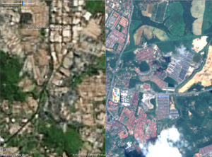
I created Sentinel-2 colour composites using ImageMagick and Adobe Photoshop CS2 / CC 2015. "Finished" composites, although not that top notch quality to be honest, are hosted on MapWarper, where all those rectification process were automagically carried out as soon as it has finished crunching at least three specified coordinates. Go ahead and use them, to improve the OSM database. TMS URLs can be obtained from the Export tab.
In short, their resolution is up to Zoom 15 levels; which means it's kind of useful to trace major highways, waterways, significant landuse e.g. landuse=constructions; but (your own) GPS tracks can reveal more. So, like it or not, ground truth is still important. And also, at least it provides something colourful to work with monochrome satellite imagery. Before having fun tracing things, PLEASE ALIGN THE IMAGERY FIRST with respect to GPS tracks and/or Strava heat maps, as usual.
From time to time, I might remove some from this collection due to a better imagery is available and/or because you know, it is nice to give extra space for the other users of Mapwarper. I may keep a copy in TIFF format (mind you, it is a 300MB+ file); so you could upload it to your own self-hosted server, or even host them on Mapbox's server for example.
It's always a good practice to mention something like this in your changesets: source=Copernicus Sentinel data [year][1]. And, oh, also, it's permissible to use these as a tracing layer.
So far, I have only created composites for few select regions in the Peninsular region. Sabahan, Sarawakian or mappers from the rest of Malaysia may request a composite (or send me a PM), but it all depends on my free time.
One more thing, these imageries are best viewed in JOSM through my experience, even on a stable 512kbps connection.
2016
March 30
- Selangor
- Extreme north regions of Kelantan and Southern Thailand (Pattani and Yala)
- Southern Perak and parts of northern Selangor
- North east Perak from Gerik to Ipoh; and from Kuala Kangsar to Titiwangsa range
April 16
- Central Terengganu: KT, eastern part of Kenyir, etc.
June 8
- Kelantan
- Taman Negara region between Kelantan, Terengganu and Pahang
- West Pahang
- Selangor
July 18
September
- Muar & Batu Pahat: Rompin, Merlimau, Machap, and Endau Rompin National Park. Acquired 3 September 2016.
- Kedahan coast: Northern extreme from Kuala Nerang. Southern extremes include west of Sungai Petani, down to the land Kedah - Penang border. And mostly northern bits of Penang. Acquired 9 September 2016.
- Kelantan: probably every jajahans except Gua Musang and Lojing. Also most of the district of Besut in Terengganu. Bit of extreme south east South Thailand. Acquired 16 September 2016.
November
- Parts of Kedah & Penang: Pokok Sena, Sungai Petani, George Town, Kulim, Sedim Tree Top Walk (LOL), straight north to Muda Reservoir. Acquired 15 November 2016.
Apparently I forgot to include the metadata
- 47NRC: Alor Gajah, Malacca City, Muar, Gemas, Rompin and Johol
- Terengganu: Kuala Terengganu, eastern bits of Kenyir, Taman Negara, Bandar Al-Muktafi Billah Shah and Marang.
2017
January
- Kelantan, Terengganu and Pahang border region. Acquired 14 January 2017.
