User:Freek
Currently mapping around Århus with a BT-747 A+.
Earlier, I worked on Nuenen (51.466,5.550, OSM map, g, mq, mm, wll, what?) and parts of Eindhoven (51.439,5.477, OSM map, g, mq, mm, wll, what?) and Helmond (51.477,5.645, OSM map, g, mq, mm, wll, what?).
Places
Places I started mapping and/or made significant contributions to:
- Nuenen
- Mapped almost completely before AND import. Surveyed all of gemeente Nuenen c.a. Buildings drawn in from aerial imagery. To do: update landuse using 3dShapes data.
- Tilst
- Streets complete, further details in progress.
- Smaller contributions:
- Den Gamle By, Århus: Streets and buildings complete.
- Legoland, Billund: Started mapping footpaths, more work needed.
- Brabrand
- Breukelen: General updates after AND.
- Leiwen: Streets (almost?) complete.
Tag scratchpaper
As opposed to Proposed_features/Scout_Camp, because I think the Dutch "blokhutten" don't fit in the "revised" proposal, but I might be wrong.
For small post boxes that are not emptied every day.
Residential roads that are not surfaced, but very accessible for normal cars and bikes. Typically compacted hardcore or pebble stone surface (track type grade 1 or 2). Mostly a shorthand for highway=residential, surface=unpaved. (I'm still using this although it's "deprecated" because I like it.)
A wall or screen restraining noise (typically from a road) from reaching residential areas. See the Wikipedia article about noise barriers.
Came across one of those and needed a tag. In my opinion this is not a footpath or a "normal" bridge and deserves a separate tag, though the highway category might not be the right one. I tagged the thing as a way from riverbank to riverbank.
What it says.
Wandelroutenetwerk
In zuid-oost Brabant wordt gewerkt aan een wandelroutenetwerk. Voor meer informatie, zie de pagina over wandelroutenetwerken.
Miscellaneous
- SVG version of the render diagram.
AND house number experiments
I have tried to convert the AND house number information to OpenStreetMap input using the Karlsruhe schema for house numbering. Although the conversion is working quite ok, the data is of mediocre quality and there is no consensus on house numbering schemes (nor is this likely to ever happen...). Some examples and more information can be found here.
The database generated by this conversion can be queried here.
Untouched AND data
I wrote a small program for visualizing the number of changes since the import of the AND data in the Netherlands. For each pixel, the ratio of the number of nodes that are not touched since the AND import to the total number of nodes in the respective area is visualized as a colour between blue via green to red.
For download:
- Source code, out of date.
- A larger version of the image to the right.
- Weekly updates.
As ITO's OSM mapper application does a lot more, a lot better, I am not planning to develop this any further.
Street coverage Denmark
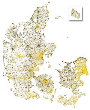
In January 2010 I made a visualization of the completeness of OSM in Denmark (shown to the right). The image is based on the per-pixel percentage of road names that appear in KMS adresses vs. OSM ways. Yellow areas such as København and Århus are (almost) complete. Black areas such as Randers and the coasts of north Sjælland are (almost) empty. White areas do not contain any KMS nodes. Other versions using different colours can be found here. A version in green & red is included in the Danish OSM promotion folder.
From October 2010, a new version is available as slippy map on osm.rasher.dk.
Reverts
On 27-02-2010 I reverted changeset 3953127 with changeset 3989142 under user revert_glaucos. The following ways have not been reverted because they were modified: 24364946 19832416 28516112 50223356 25070262 4434232 4863782
| All my contributions to OpenStreetMap are released into the public domain. This applies worldwide. In case this is not legally possible, I grant anyone the right to use my contributions for any purpose, without any conditions, unless such conditions are required by law. |

