User:Gilbert54/JOSM
Sub-pages
Imagery
Imagery provided by Bing is a bit outdated and the quality of the images is not so good.
For Flanders we have a better option: AGIV. This imagery is a lot better and also more up-to-date. Most AGIV images date from summer 2012.
Note: AGIV imagery only covers Flanders and Brussels. Not sure if an equivalent imagery resource is available for Wallonia.
Add AGIV aerial images WMS layer to the imagery options in JOSM
- Select Preferences in the Edit menu (shortcut F12). The Preferences window pops up.
- In the left panel of the Preferences settings window select WMS/TMS
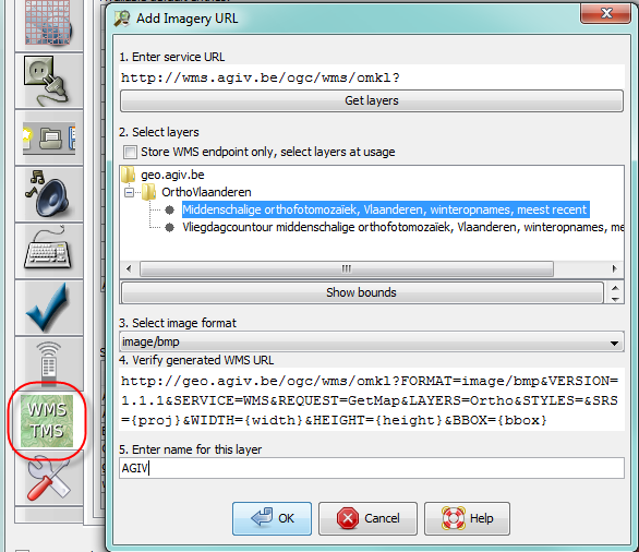
- The lower panel shows the currently activated imagery providers. Click +WMS to add a new item. The Add Imagery URL window pops up.
- Enter http://wms.agiv.be/ogc/wms/omkl? in the first field and click on Get layers
- The site will return a list with available imagery layers. Select Middenschalige orthofotomozaïek, Vlaanderen, winteropnames, meest recent; don't use the Vliegdagcontour. If you click Show bounds another window will open showing the map of Belgium with a rectangle over Flanders. This is the area covered by AGIV.
- Select the image format for the imagery overlay. The default format is BMP.
- JPEG, BMP, PNG, PNG24 and PNG32 are fine
- PNG8 or GIF works, but the images are lower in quality (noise, colour contouring artefacts)
- TIFF and SVG + XML doesn't render an image
- There may be performance differences for the different image formats, but with my high-speed internet connection I don't notice any difference in speed or image quality.
- Enter a name for this layer: AGIV
Click OK to save add he new imagery provider to the list of selected entries. Exit the preferences setting function with OK. AGIV will now appear in the Imagery drop-down selection list in JOSM.
Add AGIV GRB WMS layer to the imagery options in JOSM
The procedure to add this as a WMS layer is the same as for the aerial imagery.
- URL: http://grb.agiv.be/geodiensten/raadpleegdiensten/GRB-basiskaart/wms?
- Layer selection: GRB_Basiskaart
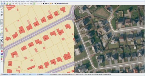
- The screenshots show the URL configuration screen and a mock-up of JOSP with with and without the GRB layer.


CAUTION: The intended use of the GRB layer is to facilitate verification the location of the house numbers. Copying/tracing of the house contours or other map details is not permitted.
