User:Gravitystorm

From OpenStreetMap Wiki
Jump to navigation Jump to search
OSM Logo This user submits data to OpenStreetMap under the name
Andy Allan.
Babel user information
en-N This user has a native understanding of English.
fr-2 Cet utilisateur dispose de connaissances intermédiaires en français.
pl-1 Ten użytkownik posługuje się językiem polskim na poziomie podstawowym.
de-1 Dieser Benutzer beherrscht Deutsch auf grundlegendem Niveau.
Users by language

I support the license
upgrade to ODbL v 1.0

ODbL-Supporter.png

I'm Andy Allan, and I'm based in London. I started helping with OpenStreetMap in October 2006.

I'm a cartographer, software developer, and small business owner.
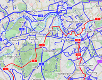
CycleLayer2.png
An international cycling map created from OSM data is available, provided by Andy Allan. The map rendering is still being improved, the data are updated every few days. It shows National Cycle Network cycle routes, other regional and local routes, and other cycling-specific features, such as:
  • dedicated cycle tracks and lanes
  • contours and hill colouring
  • bicycle parking
  • bike shops, toilets, drinking fountains, even pubs!
  • proposed bike routes (or numbering protocols), contrasted with the Lonvia map, below, which does not show proposed routes, but actual routes only

http://www.opencyclemap.org/

CyclOSM A free cycle-oriented map with more features than OpenCycleMap. See its wiki page CyclOSM.
Waymarked Trails: Cycling by Sarah Hoffman is a layer superimposed over mapnik (Standard Map Layer) which shows marked cycle routes around the world. Updated minutely, it renders actual routes without the state=proposed tag. Therefore no proposed routes (or proposed numbering protocols) are displayed.

Public-images-osm logo.svg
I support OSM by being a
member of the
OpenStreetMap Foundation
Do you?


Ivan-singing.png
I am a groupie.

Need a map was a HUGE SUCCESS.
It's hard to overstate my satisfaction.