User:LA2/Diary for Q4 2005
LA2's OpenStreetMap Diary for the 4th Quarter of 2005
December 29, 2005: During Christmas the editing applet has gone through many changes. The background satellite image is now split in tiles. Line segments stay semitransparent until they are confirmed by the server. The browser's bottom line displays the coordinate pointed at. To pan, hold shift and drag. To zoom, use the [ and ] keys. Unfortunately all new features have made the editing applet uselessly slow. Somebody (ironically, we hope) offered to donate a 266 MHz CPU to speed things up.
December 24, 2005: Merry Christmas! In the last days I've been drawing Örebro, Kumla, Fjugesta, Vretstorp, Hallsberg, Askersund, Motala and these maps are now starting to show as the old cached map tiles expire.
December 21, 2005: There is more to draw in western Östergötland: Mjölby, Boxholm, Skänninge, Vadstena.
December 18, 2005: There is now a WikiProject Netherlands in addition to the WikiProject United Kingdom. Would it make sense to start one for Sweden too? Will we ever reach outside of the rather limited area Östergötland-Stockholm? How can we reach out to other Swedes who are interested in maps, GPS, and free software or contents?
I wrote a notice at the Swedish Wikipedia village pump (Bybrunnen), and posted a similar notice to the SSLUG.teknik forum, and a page about Open Street Map on the SSLUG wiki. I also made a 468x60 OSM banner that can be featured on other websites, such as susning.nu,

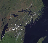
December 14, 2005: I have now drawn maps for all my tracks Norrköping-Katrineholm-Uppsala and around Söderköping and Åtvidaberg (except Mormorsgruvan). Railroad between Norrköping and Vagnhärad is not yet drawn. In the last day, someone (who?) has uploaded more tracks around Stafsjö and Kolmården (between Norrköping and Nyköping). The picture to the right shows how far OSM has come for eastern Sweden in December 2005.
December 12, 2005: I upload new tracks covering (or touching) Norrköping, Katrineholm, Flen, Malmköping, Strängnäs, Enköping, Uppsala, Stockholm (Sundbyberg, Alvik, Gröndal, Aspudden, Älvsjö), Tullinge, Tumba, Salem, Södertälje, Järna, Hölö, Vagnhärad, Nyköping. On the axis Linköping--Stockholm, these tracks follow other roads than the standard motorway E4.
December 4, 2005: The road around lake Ladoga is drawn south of 61° but the northern cap is still missing. More tracks are being added. By whom? The editing applet is seriously broken at high load, it silently and randomly drops line segments 20 seconds after I draw them. I uploaded new tracks for Finspång, Skärblacka, Söderköping, Östra Husby, Norrköping, Åtvidaberg, Rimforsa, Kisa, Gammalkil and Nykil. In the last month, the number of nodes and line segments has grown from 130K to 180K. Where will this end?
November 17, 2005: E4 is now connected all the way from Helsingborg through Jönköping and Linköping to Stockholm. What if we could find someone to drive E20 from Gothenburg over Örebro and Eskilstuna to Stockholm as well, and E18 from Oslo through Örebro and Västerås to Stockholm. From these motorways we need tracks in both directions, and every exit as well as the throughfare. How many kilometers of roads are there in Sweden, and what small percentage have we covered yet? -- More to draw in Scandinavia, where tracks are already available: Inland route in northern Sweden between 63° and 65° N, Lofoten, E4 from Stockholm through Uppsala and beyond, southwest of Oslo, western Östergötland.
November 15, 2005: E4 is now mapped from Helsingborg (N 56.05°) to Värnamo (N 57.22°). Still some way to go to Jönköping (N 57.78°), from where it is connected to Stockholm. There is also an explosion of contributions around St Petersburg, including the roads north to Murmansk, west to Vyborg, Helsinki and Turku, and south to Luga, Pskov, and Novgorod.
November 11, 2005: Steve installs the "trac" system at http://www.openstreetmap.org/trac/ but the current MediaWiki is kept. You can use the template {{ticket|5}} in order to link to ticket 5
in trac's ticket database.
October 25, 2005: Lars Aronsson (that's me) has received a grant of 50,000 SEK (5260 euro) for the development of an open GPS track log archive. My proposal was one of fifteen that received grants this year from "II-stiftelsens Internetfond", a Swedish grant fund set up by the foundation that owns the Swedish .SE top level domain. My vision is to build an open archive where projects such as OSM can retrieve track logs for drawing maps, extracting statistics, or for other purposes. I hope to find the right terms and conditions that will make people, organizations and companies willing to contribute their track logs, and would like to receive everybody's input on these issues. This new project doesn't yet have any name or other documentation. I have to report my results from this grant by the end of 2006.
October 19, 2005: The GPS track points in the OSM editing applet are now bright yellow and not invisibly dark red. Most of the map of Lambohov is now drawn.
October 18, 2005: flightlog.org is a website where Norwegian parachuters and hanggliders collect GPS track logs from their jumps and flights.
October 7, 2005: I drive around Lambohov, a south-western suburb to Linköping, and upload the track log to OSM, but fail to see the little red pixels in the new edit applet. My CRT screen is set to a high resolution where each pixel is very small, but the red color is also hard to see against the background of the brownish satellite image.