User:PaulY
I live in a small town called Winchelsea in East Sussex. Whinchelsea was founded by Edward I in 1283 to repleace Old Winchelsea which was being washed away by the sea (storms and longshore drift not global warming one assumes).
19 March 2008
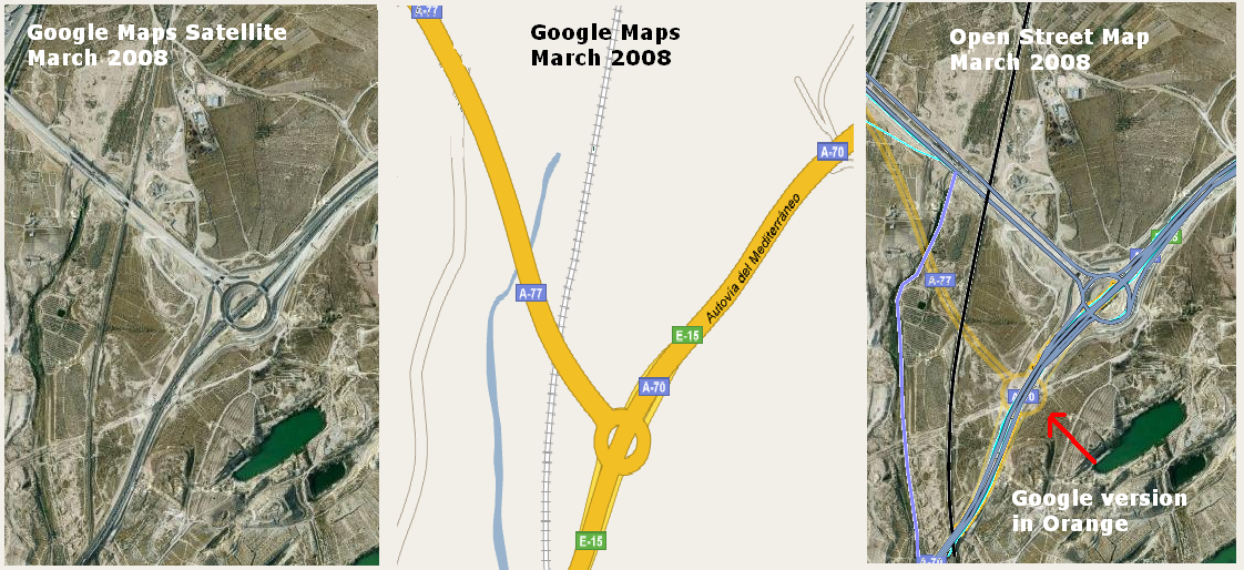
I've been doing some mapping around Alicante in Spain and noticed the difference between Google Maps version of the new junction between the A-70 and the E-15. It makes a nice comparison between them.
I'm still using my Qstarz BT-810 - I love it. But now I have it connected to my Nokia N770 PDA - which makes the whole kit much easier to carry around.
23 November 2006
Having met SteveC on Tuesday (November 21) to discuss his doing some consutancy for Yellowikis I decided to buy a second hand Garmin unit (like his) from eBay. While searching for a cheap one I discovered someone selling bargain basement Bluetooth GPS receivers - even with exhorbitant postage it came to less than £40.
It is a Qstarz BT-810). It arrived this morning and I got it connected via Bluetooth to my laptop (a Dell Latitude X1) without any problems.
Next I downloaded the trial version of VisualGPS which collects the GPS data from the receiver and saves it as an NMEA file. Once I'd got it to sync with the GPS receiver I took a walk around the garden to see if it was working then packed the laptop and the receiver in my rucsack and took a walk down to the butchers on Castle Street to get some sausages and start my OpenStreetMap of Winchelsea.
Everything seemed fine - I saved the NMEA and it looked ok, VisualGPS showed the route I'd walked and I could see the shape of the roads starting to form. Then I thought I'd go for a drive. SteveC mentioned that all of the UK Motorway system had been mapped so I thought I'd drive up the A259 and A2070 to Junction 10 on the M20 at Ashford. This would allow me to connect my map to existing data. I looped around each roundabout that I passed so I could recognise fixed points on the route - next time I will take a big lump of blutac to stop the receiver slipping around under the windscreen.
Back home after some detours to Camber, Rye Harbour and Pett Level I saved the NMEA file and downloaded GPSBabel to convert the NMEA files into GPX format to upload to OpenStreetMap.
GPSBabel gave me lots of options that I didn't really understand so I just ignored them and used the default settings - again it all worked well and I uploaded two GPX files. After a few minutes I got an email saying that my files had been uploaded and I went to investigate editing and tagging.
I downloaded JOSM Editor and I can see that this is where things get more difficult. I downloaded the first file (of Winchelesa) that I had uploaded and managed to merge it with the longer route to Ashford by simply opening the second file and flattening the layers (as you do in Gimp or Photoshop). So far so good.
I can add nodes but seem to be doing something wrong with connecting them togther with segments.
You can click on a node and add "properties" to it (i.e. Railway, Station) but I was expecting some easy way to select a road - I imagined there would be something like Magic Wand in Photoshop - do I really have to add hundreds of nodes to the A259? I need to investigate.
Looking at the recently uploaded files I can't see mine. Though they appear in when I click on the "see only your traces" link. Maybe they have to be checked by a human before being made public.
--PaulY 22:58, 23 November 2006 (UTC)
24 November 2006
This morning I got to grips with the JOSM editor.
OSM'd the A2070 from J10 of the M20 in Ashford to Brenzett then down the A259 all the past Rye and Winchelsea to Icklesham. I worked out how to do juctions/roundabouts and mark roads. Then I saved my OSM file and uploaded it. Now I am waiting for it to appear on the OSM map.
I noticed that my sister's road in Forest Hill was misspelled (Garlied instead of Garlies) so I worked out how to get a map into the JOSM Editor from a map URL on OSM. Very smart. That whole area of SE London has been OSM'd really nicely. Corrected the spelling and uploaded the change.
Used the same system to look at other traces in the Winchelsea/rye area. Disovered that there was already a trace but it had far fewer nodes than mine so I "tidied" it up.
Noticed that I've been mislabeling the A259 "Trunk" when it should really be primary. Will have to go back and re-tag it.
26 November 2007
Took my laptop and GPS receiver on the train from Eastbourne to Hastings. Got a very stong signal all the way, the tunnels don't seem to present any particular problem - need to investigate how to tag them though.
