User:RalfZ
| This user submits data to OpenStreetMap under the name RalfZ. |
I support OSM by being a
member of the
OpenStreetMap Foundation
Do you?
About myself
My Name is Ralf Zimmermann. Since Juli 2010, I am living in the northern part of Regensburg, Germany.
I used to live in Munich-Trudering (48.122°N, 11.655°E) see on OSM map, Germany, where I contributed a lot to the OSM data in and around Munich.
OSM Maps for Pathaway
I have converted some OSM maps for the use with Pathaway on PDAs.
OSM Mapping I have done
Sep-2006: Started mapping München-Trudering
Oct-2006: Participated in the Munich Mapping Weekend
Dec-2006: Fully mapped Wiesbaden-Naurod
Dec-2006: Fully mapped Hirschberg Leutershausen
Feb-2007: Continued mapping in Neubiberg near Munich
Mar-2007: Did a lot of mapping in Karlsruhe during the mapping weekend, 31-Mar and 01-Apr.
Apr-2007: During a business trip to the UK, I did some mapping in Banbury and to the North-West of it.
May-2007: During a business trip to the UK, I did some mapping in the area of Heathrow.
June-2007: During a business trip to Schweden, I did some more mapping in Gothenburg. Area1 Area2
During a business trip to the UK, I did some mapping south-east of Coventry.
July-2007: During a business trip to the UK, I did some more mapping in the area of Heathrow.
05-Jul-2008: Mapping-Weekend: Landsberg
27-Jul-2008: Süd-Osten von Diessen, Eching am Ammersee komplett, Teile von Utting am Ammersee
28-Jul-2008: Seefeld
16-Aug-2008: Mapping-Weekend: Gerolfing und Teile von Ingolstadt
30-Aug-2008: Purfing, Anzing, Oberasbach, Unterasbach, Heiligkreuz
31-Aug-2008: Großhelfendorf, Kleinhelfendorf, Göggenhofen und Neugöggenhofen
Sep-2009: Some mapping during my sailing trip in Greece (Dodekanes)
Nov-2009: Some small mapping in China during a business visit (Shanghai, Guangzhou)
Mapping done with satellite pictures
I have used satellite pictures from Landsat (in JOSM) and Yahoo (with the online applet) for mapping areas that I know:
Mar-2007:
- Kalamaki Harbour in Athens, Greece
- Lavrion Harbour in Greece
- Sounion Bay in Greece
Equipment for OSM
Garmin Nüvi 200W
In September 2008, I bought a Nüvi 200W. This is a stand-alone unit from Garmin for vehicle navigation. It came loaded with Maps for Germany, Austria, Switzerland and Tschechien. I paid 109 EUR for it.
The first thing I did was loading a routable OSM map from [1] onto the SD-card which I put into the Nüvi. And of course I disabled the pre-loaded data from Garmin.
This unit serves two purposes. Firts, having a stand-alone unit that helps me navigating easily. Secondly, checking OSM data for routability. When the Nüvi uses the converted OSM data for calculating routes, it will give me hints about wrong or misleading OSM data. This way I am finding problems in the OSM database that hinder good routing.
After one week of using the Nüvi, I have the following observations:
- Compact unit, even working several hours without external power
- Really good display, perfectly readable in the summer sun
- Easy to use, no buttons - just touch-screen
- Routing is pretty fast
- Even with the problems existing in the OSM database, the routes created are pretty usable.
- Some of the POIs from the OSM database are accessible in the Garmin POI categories.
- Very usable with OSM data and not expensive!
Nokia N810
In June 2008, I bought a Nokia N810. The biggest reason for this was the application Maemo Mapper that exists for the N770/N800/N810 devices.
Maemo Mapper
Here are the URLs for using several map sources in Maemo Mapper:
| Google Maps Terrain | http://mt.google.com/mt?v=w2p.87&x=%d&y=%d&zoom=%d |
| OSM Mapnik | http://b.tah.openstreetmap.org/Tiles/tile/%0d/%d/%d.png |
| OSM Tiles at home | http://b.tile.openstreetmap.org/%0d/%d/%d.png |
BlueGPS RBT-3000
I am mostly using a RoyalTek BlueGPS RBT-3000 Bluetooth GPS receiver. This unit has built-in memory for storing track data. The unit is very reliable and has served me well for two years.
Amaryllo Trip Tracker Bluetooth
Bought in 2006.
A few months ago, I also bought a Amaryllo Trip Tracker (Bluetooth) from Amaryllo.
This unit stores track data onto SD card. The Trip Tracker has the problem that it does not work with all SD cards.
I finally found a 512MB card from Kingston that works fine with it.
Overall, I am not content with the receiver sensitivity. It happens a lot, that in city canyons my old RBT-3000 still records a usable track when the Amaryllo already has lost the satellites and stopped logging. I am not using this GPS for OSM anymore.
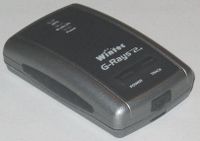
Wintec WBT-201
Bought in Apr-2007 for 109 EUR.
I bought this GPS receiver to replace the RBT-3000, which does not have good receiver sensitivity.
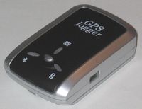
Transystem i-Blue 747
|
|
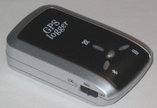
Bought in Aug-2007 for 41,20 EUR (eBay)
I am content with my WBT-201, but I have read that the i-Blue 747 allows full flexibility in determining which GPS values get logged into the memory of the device. This is why I bought this GPS even though it almost duplicates the functionality of the WBT-201.
APC Mobile Power Pack, 10Wh
When I am out mapping, I have the APC mobile power pack with me. With its USB connector, I can re-charge my GPS and PDA.
The power pack itself gets charged via the small USB connector.
Link to manufacturer page: www.apc.com
Bike holder
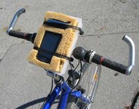
I made a holder for my bike, which holds the Bluetooth receiver and my Palm OS handheld in place while riding my bicycle.
The holder provides shock and vibration protection and can easily attached and detached from the handlebar.
So far, it worked nicely for my mapping trips.

