Utah/Naming Conventions/Activity
- Welcome to tonight's social gathering sub-activity!
- Sub-activity name: 370 S. 300 E.: Utah's Unique Addresses
- Sub-activity duration: One minute.
- Sub-activity time: Each guest just notices the Salt Lake City street name signs sometime during the conference. Best tonight when downtown. We will try to point them out to guests during the evening. Guests also red all about the addressing system via this page.
370 S. 300 E.?
Here we are at the State of the Map U.S. 2024 Thursday, June 6 evening social event and Martijn van Exel is pointing out the street name signs outside the venue, 370 S. 300 E. Salt Lake City, Utah.
But what does that address mean? Does it mean that some of we serious map people might, Lord forbid, get lost trying to find it on our own?
Grid values as street names
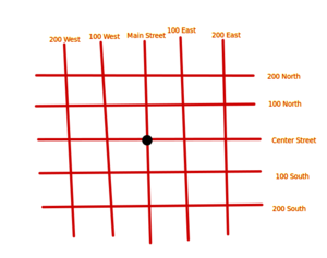
Well, it turns out, in Utah, very often, the address grid values are the street names!
Utah addresses are unique from other states because of a strong address grid system [which] enables us to make special assumptions and optimizations[1]
Whereas in other states [2] you might have "Nibblesworth Avenue (700 East)", or "7th Avenue (700 East)", in Utah they mostly just simply toss out the window dressings, and all you have left is "700 East". Yet life somehow still manages to go on.
Origin point: Salt Lake Meridian and base line
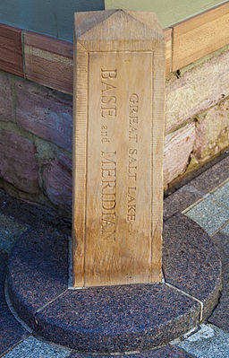
OK, it's not the end of the world. But OK, where does it begin? Where's the 0 N. 0 E. origin point? This is the place, perhaps?.
Close, but it actually starts at the much smaller monument Meridian marker. Alas, temporarily closed in 2024.
In OSM data we actually find a second "correct position" node too, 2.3 meters to the southeast. (echo 40.7695353 -111.8913520 40.7695181 -111.8913354 | geod -f %.1f +ellps=WGS84 -I gives: 143.7 -36.3 2.369.)
- Q: Actually wouldn't the Public Land Survey System (PLSS) corner be a few feet away, in the middle of the intersection, of South Temple and Main St.?
- A: No. Looking at USGS topographic maps, you will see the PLSS is rather disassociated from the street grid of Salt Lake City! No PLSS on this plat.
Videos
- How The Salt Lake Grid System Works
- Narrator mentions it is life changing for her.
- Salt Lake City's Map, Explained
- Streets of Salt Lake City explained
- The Logic Behind Salt Lake City's Streets
Articles
- Utah/Naming_Conventions
- How to Navigate Salt Lake City Street Addresses
- Salt Lake City and County Street Names and Numbers
- Wikipedia:Salt Lake City#Layout ; #Roads
- Why don't all cities number their streets this easy way? (Utah Method)
- How did Utah end up doing their addresses so weird in comparison to every other state?
- Salt Lake City, Simplified
- We learn that the street names in the past weren't always so well planned.
- Wikipedia:Mormon settlement techniques of the Salt Lake Valley#The_grid
- The Lyman or Salt Lake City System
- https://gis.utah.gov/the-western-grid/
- https://www.ucls.org/utah-surveying-history
- How everything in Utah is connected to Temple Square
- The center of the city
- The standard in Salt Lake is 8 blocks to a mile, but only if you are counting it by address numbers. When you take the width of a street into it, it's 7 blocks.
- https://www.howderfamily.com/blog/salt-lake-meridian/
- https://www.google.com/search?q=Salt+Lake+City+block+sizes
- https://www.google.com/search?q=How+to+navigate+Salt+Lake+City+street+addresses
Questions
- Q: What is the correct way to mentally parse "370 S. 300 E."?
- A: 370 ( S ( 300 E ) ).
- Q: What would 370 S. 300 E. be in your home town?
- A: 370 S. 3rd St. E. in mine. How about yours?
- Q: If you were to start over, how would you make Salt Lake City's street name / address system even more "powerful"? What would "370 S. 300 E." become?
- A: 75000 + -370, 25000 + 300 => 74630 N. 25300 E.! Sort of like Edmonton, Alberta, but getting the most out of those five digits... But that's just one "solution"...
- Q: Locate 370 S. 300 E., given the locations of some nearby street corners.
- A: See https://gdal.org/programs/gdaltransform.html#ground-control-points We used the baseline (South Temple), meridian (Main Street), 500 S, and 500 E. (By the way, earlier in this wiki page we showed the corner of 500 N and 500 W.)
Notes
Yes, in many parts of the world places unfortunately don't have address grids, or even addresses.
People
- Add your name here! And feel free to edit this entire page.
- User:Mvexel Person who will point out the street signs to guests there that evening.
- User:Jidanni jidanni@jidanni.org Behind the scenes person who is writing most of this stuff. His wants real bad to put address grids back on the map. See also [3].
Tasks
All that needs to be done:
- Staff includes the first page of this Utah/Naming_Conventions/Activity page in the printed conference materials, if any.
- Martijn et al. points out the 300 East street name sign outside the Thursday evening venue. Or if everybody is already inside, simply reminds them to be sure to notice the street signs while in town this evening. (True, the 400 S. sign at that intersection does have a nickname on it, in smaller letters, "University Blvd.".)
- Conference participants scan the QR-code in their leisure to see this full Utah/Naming_Conventions/Activity page.
Welcome to reuse this page, editing it for future activities.


