WikiProject Val Thorens France
| This page is about the Past Event in December 2006. For current mapping status, see WikiProject Piste Maps/Les Trois Vallées. |

Past Event in December 2006. A week long mapping party in the highest ski village in Western Europe.
In what must surely be the very last mapping party of the year, OpenStreetMappers will be venturing further and higher than ever before to map the pistes of les Trois Vallées.
A truly international event, in the heart of the French Alps close to the Italian border this event is accessible to OpenStreetMappers from almost anywhere in Europe.
Results
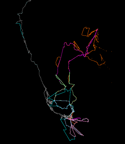
This image is a composite of all the track logs from the mapping party. It covers Val Thorens, Les Menuires, Meribel and Courchevel. Because snow cover was very light not all lifts were open. Coverage is far from 100% of all lifts and pistes. I guess we'll have to make a second visit sometime :-)
OSM map of Val Thorens. Looks like just the road got tagged. Any examples of piste maps there?
What
- What - A week long OpenStreetMap Mapping Party at the Val Thorens ski resort.
- Aim - To map all the lifts and pistes in Val Thorens and as much of the rest of les Trois Vallées as possible.
- Who - Open to all, but not suitable for non-skiiers/board riders.
- I can't ski or anything, but can stay at the bar to look after the laptops :D. I can also do the car-enabled streets and stuff (user:sxpert)
- How - On skis or snowboard. If you have them also bring:
- A GPS receiver that can create tracklogs (ie remember where you traveled)
- A digital camera (or dictaphone)
- Altimeter (GPS altitude measurements are not very accurate)
- GPS units will be available on loan if you need one.
When
- The week before christmas: Saturday 16th December through Friday 22nd December 2006.
- Come for a week, or a weekend or just for a day or two.
- Its Boarderweek. Toujours plus fort!
- This is low season so prices will be, ahem, more affordable.
Where
- Val Thorens, France. The highest ski village in Western Europe at 2300m.
- The main meeting point will be the Place de Caron in the centre of Val Thorens
- The snow has arrived: webcam
About Val Thorens
- Western Europe's highest ski village. Altitude 2300m.
- 2.5 hours from Lyon, 3 hours from Geneva, 2 hours from Torino.
- Part of the Trois Vallee ski area, which includes Courchevel, Meribel and Les Menuires as well as Val Thorens.
- Over 200 lifts, 600km of piste and 130km of langlauf trails need to be mapped.
- Skiing, Snowboarding, etc.
- SkiClub overview
- Official website
- Live webcam
Programme of Events
- Saturday - ski / snowboard / après-ski
- Sunday - ski / snowboard / après-ski
- Monday - ski / snowboard / après-ski
- Tuesday - ski / snowboard / après-ski
- Wednesday - ski / snowboard / après-ski
- Thursday - ski / snowboard / après-ski
- Friday - ski / snowboard / après-ski
Weather Forecast
- Snow
Who's interested in the Mapping Party?
Please add your name if you plan to come along just so we get an idea of numbers and experience.
- Etienne will be there all week
- User:Justin will be there all week
- User:David will be there all week
- User:Sxpert probably only the weekend
Getting There
By Train
- TGV from Paris, London (Eurostar), Brussels, Lyon to Moûtiers. Bus or Taxi from Moûtiers to Val Thorens.
By Road
- From Chambéry take the A43/E70
- From Torino via the Tunnel du Fréjus to Orelle in the Maurienne valley.
- Approx 10 hours drive from Calais
By Air
- Lyon - 190km - transfer via coach
- Geneva - 160km - transfer via coach
- Chambéry - 110km - transfer via coach
Packages
There are plenty of tour operators that provide package deals to Val Thorens. Can often be the best value.
Getting around
Val Thorens is a car free resort.
Somewhere to stay?
Lots of choice, from micro studio apartments to luxury chalets and hotels.
- Online reservations at http://www.valthorens.com
Mapping
Trois Vallées
The ski area is made up of four valleys:
- Courchevel: Le Praz, Courchevel 1550, Courchevel 1850
- Méribel: La Tania, Méribel, Mottaret
- Belleville: St Martin, Les Menuires, Val Thorens
- Maurienne: Orelle
Gathering Points of Interest
On your travels, look for the following, record their positions, and photograph if possible:
- Lift stations (name, altitude, etc)
- Lifts (type, capacity, etc)
- Mountain restaurants
- Mountain huts/refuges etc
- Piste gradient
Finding out more
- Contact Etienne
