2023 Afghanistan Earthquake
| General Information | |||||||||||||||
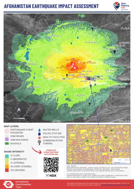
AFGHANISTAN EARTHQUAKE Two earthquakes, both with a magnitude of 6.3, struck Herat Province of Afghanistan on 7 October 2023. The first earthquake struck at 11:11 AFT followed by the second shock 31 minutes later. These earthquakes left at least 2,530 people dead and 9,240 others injured. The earthquake was Afghanistan's deadliest since 1998. Please contribute to this project to locate buildings and settlements in the affected region for urgent mapping. | |||||||||||||||
For Aid Organizations
Map and Data Services

Exporting OpenStreetMap data
See Downloading data for instructions on getting large scale map data, or see the focused exports below:
- HDX for HOT in Afghanistan (data refreshed every 1 month, previously 6 hours based on the download frequency).
Accessing MapSwipe Data
A MapSwipe mission was created on 8 October 2023 covering this area of interest and was quickly completed by 9 October 2023. Contributors were asked to tap image tiles where they see buildings. The mission displayed Esri World Imagery at zoom level 17 with a 'verification number' of 3. This means that 3 people need to see every image tile before it is considered finished or 'fully swiped'. To access the MapSwipe data outputs visit this MapSwipe website page. The 'HOT Tasking Manager Geometries' output was used to generate the Tasking Manager project titled Earthquake Response in Herat, Afghanistan 2023 (1) to focus contributors efforts in areas where buildings were identified.
About This Disaster Activation
About HOT

To learn more about the Humanitarian OpenStreetMap Team (HOT), explore more of our wiki-pages (root: HOT) or our website hotosm.org. HOT is a global community, mostly of volunteers, and it is a US registered nonprofit able to contract with organizations (email info at hotosm.org to contact our staff), we are also a 501(c)(3) charitable organization.
History of this Activation
OSM Community Activation
8 Oct, 2023 - Following the event, mappers from Afghanistan and staff from HOT agreed to launch an activation to support response efforts. Conversations with the local mappers around the damage caused by the floods earthquake, priorities for mapping, their capacity to coordinate and engage, and the technical aspects of Tasking Manager projects happened on via private messaging and HOT Slack Workspace channel #disaster-mapping which is bridged through Matrix.
Coordination
- Lead(s):
- Mikko Tamura (Coordination Lead)
- Geoffrey Kateregga (HOT Tasking Manager support)
Data Quality
All contributions through HOT's Tasking Manager are tracked with a unique changeset comment tag: #AfghanistanEarthquake2023.
Validation
Validation permissions for Tasking Manager projects are restricted to particular Tasking Manager Teams / users to ensure high quality validation:
- OSM Afghanistan
- HOT Global Validators
- Validator Trainees
- OSM Africa Validators
- MSF Validators
- Data Quality Interns
- Data Quality Interns 2022
OSMCha
A specific OSMCha filter can be used to detect data quality issues across a wider area.
Overpass Turbo
A specific Overpass Turbo query can be used to check the data quality regularly. Open it in JOSM and run validation (Shift+V).
For Mappers
How You Can Contribute
Learn to Map
- Most of our volunteer needs are for remote OSM contributors, visit LearnOSM.org to get started.
- The buildings in this area of Afghanistan are not easy to map, often tightly clustered. Please read the Tasking Manager instructions carefully and take your time to ensure quality contributions.
Mapping Priority
- Please choose from highest priority first
- Experienced mappers are also asked to participate in validating completed tasks. Information on validating can be found here
| Project | Priority | Name | What to map | Imagery Source | Task Mapping Status % | Task Validation Status % |
|---|---|---|---|---|---|---|
| ACTIVATION PROJECTS | ||||||
| 15658 | Ongoing | EARTHQUAKE RESPONSE IN HERAT, AFGHANISTAN 2023 | Buildings | ESRI World Imagery; Bing Imagery as 2nd option | 100 | 80 |
| 15693 | Ongoing | Earthquake Response in Herat, Afghanistan 2023 - ROADS | Roads | ESRI World Imagery | 92 | 45 |
Community Mapathons
| Date | Time | Lead Community | Country | Location/ Meeting Link/ Registration Link | Type | Status | Notes | Social Media Post |
|---|---|---|---|---|---|---|---|---|
| 2 |
MapSwipe
A MapSwipe mission was launched on 8 October 2023 and completed the next day to pin down building and settlement locations to trim down mapping area priorities.
- First completed MapSwipe mission with data outputs
- uMap of MapSwipe mission coverage - others may be added in due course
Available Imagery
ESRI World Imagery
ESRI World Imagery is relatively the clearest and most updated imagery among the others in this area. Tasking Manager contributors are told to use ESRI World Imagery as their first option (and it loads by default). However, contributors are instructed to check other imagery sources such as Bing Imagery if there are clouds or no high-resolution imagery available. Contributors are told to align the imagery with existing/mapped features if necessary.
How to add/use Alternative Imagery
With JOSM, it's relatively easy to add special imagery if the license is appropriate for tracing into OSM. For more details see JOSM Imagery Help
