Alminav
| Alminav | ||||||||||||||||||||||||||||||||||||||||||||||||||||||||||||||||||||||||||||||||||||||||||||||||||||||||
|---|---|---|---|---|---|---|---|---|---|---|---|---|---|---|---|---|---|---|---|---|---|---|---|---|---|---|---|---|---|---|---|---|---|---|---|---|---|---|---|---|---|---|---|---|---|---|---|---|---|---|---|---|---|---|---|---|---|---|---|---|---|---|---|---|---|---|---|---|---|---|---|---|---|---|---|---|---|---|---|---|---|---|---|---|---|---|---|---|---|---|---|---|---|---|---|---|---|---|---|---|---|---|---|---|
| Author: | almica | |||||||||||||||||||||||||||||||||||||||||||||||||||||||||||||||||||||||||||||||||||||||||||||||||||||||
| License: | Proprietary (free, InApp payment) | |||||||||||||||||||||||||||||||||||||||||||||||||||||||||||||||||||||||||||||||||||||||||||||||||||||||
| Platform: | Android | |||||||||||||||||||||||||||||||||||||||||||||||||||||||||||||||||||||||||||||||||||||||||||||||||||||||
| Version: | 3.1.5 (2022-07-01) | |||||||||||||||||||||||||||||||||||||||||||||||||||||||||||||||||||||||||||||||||||||||||||||||||||||||
| Languages: | German and English
| |||||||||||||||||||||||||||||||||||||||||||||||||||||||||||||||||||||||||||||||||||||||||||||||||||||||
| Website: | in googlePlay | |||||||||||||||||||||||||||||||||||||||||||||||||||||||||||||||||||||||||||||||||||||||||||||||||||||||
| Install: | ||||||||||||||||||||||||||||||||||||||||||||||||||||||||||||||||||||||||||||||||||||||||||||||||||||||||
| Programming language: | Java | |||||||||||||||||||||||||||||||||||||||||||||||||||||||||||||||||||||||||||||||||||||||||||||||||||||||
|
Android offline navigation - Mapsforge vector maps - Offline route calculation - Display maps with contourlines - GPS recording as kml or gpx file - Import KML and GPX routes - Elevation and velocity charts |
||||||||||||||||||||||||||||||||||||||||||||||||||||||||||||||||||||||||||||||||||||||||||||||||||||||||
| ||||||||||||||||||||||||||||||||||||||||||||||||||||||||||||||||||||||||||||||||||||||||||||||||||||||||
Alminav is an Android navigation app for hiking and cycling
Alminav is designed for hikers, cyclists, and other outdoor enthusiasts. One of its main advantages is that it can function offline, as signals in the rural areas are often very weak. Maps can be downloaded in advance, and are vectored so as to not take up a lot of space in the phone's storage. Poi databases offer the option to explore on the map cities, streets, restaurants, accomodations, doctors, banks, sport areas, mountains, attractions and more. For trips between two places, the app can plan a walking, biking or car route. You can opt for the fastest or shortest routes. Navigation works offline with downloaded maps.
Features
- Map view using vector maps (MapsForge format) with OpenStreetMaps data
- Offline route calculation
- Display maps with contourlines
- GPS recording as kml or gpx file
- Import KML and GPX routes
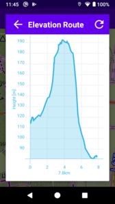
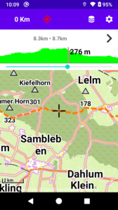
- Elevation chart
- Velocity chart
- Street search
- City search
- Poi Database
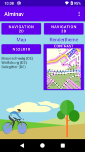
2D and 3D View
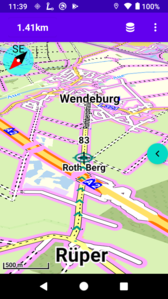
Two views are available for navigation: 2D and 3D. Both views are using the same data, but have some differences in the user interface and menu structure. The 3D view has some additional functions:
- Display of the map in the direction of travel
- The map can be displayed tilted (in perspective)
- Buildings are shown 3-dimensional in large zoom levels
- Display of multiple routes
- Display of marked cycle paths (in Germany)
- Alminav: Navigation for cycling and hiking
Maps
Map tiles
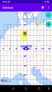
The map tiles are all the same size and cover the rectangular area from one longitude and one latitude. Example: The tile n48e005 covers the area between the latitudes north 48° and 49° and between the longitudes east 5° and 6° (area about 100x100km). These tiles have a small download size, the route calculation is fast, they cover large parts of Europe.
For the area of Germany, marked cycleways can be displayed in the 3D view.
Country maps
Road maps of the European countries are available and can be used after upgrade.
Upgrade
The limitation of maps import can be removed by in app purchases. One map tile can be imported for free.
Apis
- Vector maps rendering: mapsforge wiki
- Route calculation: http://graphhopper.com
Changes
- Version 3.1.3 (20. Mai 2022)
- - Show list of photos with location information - Import photos with location information as placemark
- Version 3.1.2 (6. Mai 2022)
- - GPS Statistics corrections - Bugfix: Crash when finishing navigation without GPS fix - Bugfix: Removing placemark in 3D did not work correctly
- Version 3.1.1 (14. Apr. 2022)
- - Improved display and management of routes and placemarks - Bugfixes
- Version 3.1.0 (28. März 2022)
- Bugfix: Crash when displaying poi categories
- Version 3.0.9 (24. März 2022)
- Bugfix: Crash of 3D navigation on first installation
- Version 3.0.8 (20. März 2022)
- - New route collection: Roundtrips in Germany - GPS stats with Altitude from SRTM terrain elevation data - Menu item with route collections: German trails, former railway lines, roundtrips, favorites
- Version 3.0.7 (4. März 2022)
- - Trip Management and display of statictics improved
- Version 3.0.6 (22. Feb. 2022)
- - Route placemarks showing distance - Gps stats display does end automatically - Gps stats display is updated with new values - Bugfixes
- Version 3.0.5 (8. Feb. 2022)
- - Improved interaction between location service and navigation activity - Improved interaction between notification component and navigation activity - Navigation activity can be stopped from notification - Tracks can be created by saving trips, they are no longer created automatically.
- Version 3.0.4 (27. Jan. 2022)
- - Management and Download of maps improved - Settings dialogues (general and routes) improved - Bugfixes
- Version 3.0.3 (17. Jan. 2022)
- - Directory of bike paths on former railway lines - Minor improvements
- Version 3.0.2 (30. Dez 2021)
- - Main activity with new layout - Bugfixes
- Version 3.0.1 (24. Dez 2021)
- Version 301 - Bugfix: Crash when starting download of german trails Version 299 - German bicycle trails can be downloaded and used - Main activity with drawer menu
- Version 3.0.0 (21. Dez 2021)
- Version 300 - Bugfix: Crash when starting download Version 299 - German bicycle trails can be downloaded and used - Main activity with drawer menu
- Version 2.9.8 (1. Dez 2021)
- Bugfixes and minor improvements
- Version 2.9.7 (17. Nov 2021)
- - Faster initialization of route preview - Changes for Android 12
- Version 2.9.6 (5. Nov 2021)
- - Route simulation - New Rendertheme Outdooractive - Display of route gradient improved - Visibility of placemarks can be changed
- Version 2.9.4 (21. Sep 2021)
- - Setting for GPS update interval - Use of the magnetic compass in 3D - Display of some elements with animation
- Version 2.9.3 (3. Sep 2021)
- - New function: Create round courses - New function in 2D: Show additional map tiles
- Version 2.9.2 (23. Aug 2021)
- - Dialogues have a more uniform layout - Export and import of route data
- Version 2.9.0 (4. Aug 2021)
- - Simplified menu structure - Less differences in the 2D and 3D menu structure
- Version 2.8.9 (17. Juli 2021)
- - Routes are displayed as placmarks in the map - Routes are included in the placemark list - Route preview images can be created in 3d view - Routes overview in top level menu
- Version 2.8.8 (28. Juni 2021)
- - Routes overview in main menu - If there is a deviation from the route, a line to the next route point is displayed - Search fields for route names and poi names with history - PDF document with route preview images can be created and shared
- Version 2.8.7 (9. Juni 2021)
- Selection dialogs with icons: - Country selection in city list - Settings for route display - Accuracy when recalculating routes
- Version 2.8.6 (4. Juni 2021)
- - Show route instructions for calculated routes - Show nearest Pois with GPS values
- Version 2.8.5 (15. Mai 2021)
- Context menus are displayed - when tapping on a Poi - when tapping on a route line - when tapping on the crosshair - when pressing long within the map area
- Version 2.8.4 (5. Mai 2021)
- Map download is running within a service and can run in the background
- Version 2.8.3 (27. Apr. 2021)
- - Creation of route preview images when saving in the 2D-view - Loading routes from preview images - Bike bell in the speedometer
- Version 2.8.2 (19. Apr. 2021)
- Better handling of map errors and more user interface improvements
- Version 2.8.0 (11. Apr. 2021)
- - Route tracking (click on route line) shows current position on the elevation profile - GPS-values can be shown together with a speedometer - Maps can be downloaded from topographic world map - Bugfixes and improvements
- Version 2.7.9 (27. März 2021)
- - A map grid with download function can be displayed in the 3D view with world map - Topographic Worldmap - Topographic maps for countries Germany, Austria, Switzerland, Belgium and Netherlands - Bugfixes and improvements
- Version 2.7.8 (13. März 2021)
- - Route management dialogues improved in 3D-view. - Internal change: Use of Android Api 30.
- Version 2.7.7 (4. März 2021)
- - Use of topographic raster maps for Germany and the Alpine region - Bugfixes and improvements
- Version 2.7.5 (24. Feb. 2021)
- - Location service improved, unnecessary authorizations removed.
Version 2.7.2 (12. Feb 2021)
- New simplified User Interface.
- Only 1° x 1° map tiles and country maps are used.
- Only cycleway overlays are used.
Version 2.7.0 (5. Dez 2020)
- Map management improved
- Show buildings in three dimensions again and more bugfixes
- Pois can be exported and imported to external files
Version 2.6.9 (20. Nov 2020)
- Bugfix: Android 6 crashes when starting App
- Dialogues for map management improved
Version 2.6.8 (19. Nov 2020)
- Bugfix: Android 6 crashes when starting App
- Dialogues for map management improved
Version 2.6.7 (15. Nov 2020)
- Bugfix: Overlay maps cannot be downloaded
Version 2.6.6 (6. Nov 2020)
- New map style 'Contrast'
- 3D-View: Selection of map aned overlay combined in one dialog.
Version 2.6.5 (13. Okt 2020)
- Click on route shows elevation diagram with menu access, route markers with numbers removed
- Map tiles can be selected for download with a click
- Show pois in list with latitude and longitude
- Bug fixes
Version 2.6.4 (2. Okt 2020)
- New Design for these context menues: Vehicle selection, trips, routes, maps
- Bugfixes
Version 2.6.3 (9. Sep 2020)
- 3D-View: When loading a route from file, simple instructions are generated with the distance to the destination.
- When calculating the route, the information has been expanded to include the distance to the destination.
- The component for the route playback has been extended with the option to update the altitude values.
Version 2.6.2 (2. Sep 2020)
- New animation for navigation button.
- 3D Map-View: Show pois with name.
- Bugfix: 'Save GPS log' causes crash.
Version 2.6.1 (26. Aug 2020)
- List of saved routes with filter function
- New button in sidebar enables quick access to routes
- Start/Destination dialog enables Pois list view
- Bugfixes
Version 2.6.0 (17. Aug 2020)
- Corrections for country map download
- Corrections for shortcuts
Version 2.5.9 (10. Aug 2020)
- 3D-View: GPS marker is displayed in perspective.
- 3D View: GPS marker is no longer covered by the route.
- Changes for Android 10 Compatibility:
- All the time location permission is required for background tracking.
- App Update: The permission has to be set manually in app settings.
Version 2.5.8 (1. Aug 2020)
- 3D-View: New option for map shift down
- Bugfixes
Version 2.5.7 (22. Jul 2020)
- Launching of route shortcuts improved (Shortcuts have to be renewed)
- New map rendertheme
Version 2.5.6 (9. Jul 2020)
- Main view layout changed
Version 2.5.5 (2. Jul 2020)
- Resets general capitalization in 3D-View
- Fixes a problem with the purchase
Version 2.5.4 (1. Jul 2020)
- Resets general capitalization in 3D-View
- Fixes a problem with the purchase
Version 2.5.2 (27. Jun 2020)
- Correction for adding a route destination (3D-View)
- Bugfixes
Version 2.5.1 (16. Jun 2020)
- 3D-View: Improved display of route and gps path
- Minor improvements and bugfixes
Version 2.5.0 (8. Jun 2020)
- App description improved
- 3D-View: Fast access to visible pois with long click on poi in map
- Show main menu items with icons
Version 2.4.9 (2. Jun 2020)
- Fast access to routes and tracks with long click
- Improvement of route menus
- Map alignment can be coupled to magnetic compass
- Bug fixes
Version 2.4.8 (22. Mai 2020)
- 3D-View: Route can be displayed with direction arrows
- 3D-View: GPS path is displayed with direction arrows
- Improved user interface and bugfixes
Version 2.4.7 (10. Mai 2020)
- Added Europe overview map with zoom level up to 10
- Added layer for overview map sections with zoom levels up to 12
- Bugfixes
Version 2.4.6 (27. Apr 2020)
- New: Trip statistics with menu for save, delete and charts
- Bugfix: Trip statistics disappears after changing screen orientation
- Bugfix: 3D-Component haircross position is a little bit down
- Bugfix: Some views in 3D-component are covered by the toolbar
Version 2.4.5 (20. Apr 2020)
- No Gps restart is required when orientation changes
- Click on gps notification shows gps charts
- Bugfixes
Version 2.4.4 (3. Apr 2020)
- Improved poi management
- Bugfixes when changing screen orientation
Version 2.4.3 (24. Mär 2020)
- Database initialization is possible to run in background
- Download is possible to run in background
Version 2.4.2 (11. Mär 2020)
- Bugfixes and improvements when changing screen orientation
- Faster initialization with predefined cities database
Version 2.4.1 (28. Feb 2020)
- Management dialog improvements for maps, pois and routes
- New map type 'Small Tiles'
Version 2.4.0 (23. Feb 2020)
- List of country maps with national flags
- List of available maps with national flags
- Correction: List of download files for one map has been completed
Version 2.3.9 (20. Feb 2020)
- Bugfix: First time initialization crash
Version 2.3.8 (19. Feb 2020)
- Added new rendertheme
- Dialog and layout improvements
Version 2.3.7 (24. Jan 2020)
- 3D: Hillshade opacity can be changed
- 3D: GPS path can be displayed
- Improved management and display of routes
Version 2.3.6 (11. Jan 2020)
- Correction: Route instruction fragment is no longer covered by compass.
- Bugfix: Crash in map overview when orientation changes.
- Bugfix: Crash when leaving app while route is calculated.
Version 2.3.5 (2. Jan 2020)
- Management of country maps and map layers simplified.
- Coverage of hillshade areas enlarged.
- Bugfix: Crash when selecting DBCities in database list.
Version 2.3.4 (27. Dez 2019)
- Bugfix: Crash when calling upgrade from menu
Version 2.3.3 (6. Dez 2019)
- 3D View: New Map layers for hillshade and waymarked cycleways
Version 2.3.2 (24. Nov 2019)
- 3D View: Using raster maps for lower zoom levels.
- New: Search for address.
- Bugfix: Orientation change in map overview causes crash.
Version 2.3.1 (12. Nov 2019)
- 2D View: Using raster maps for lower zoom levels (it may be necessary to clear the cache after updating).
- Improved maps overview with raster maps.
- Bugfix: Gps was restarted after finishing app in some cases.
- Bugfix: Crash when loading second route.
App size has increased as it contains raster maps for small zoom levels.
Version 2.3.0 (15. Okt 2019)
- Internal changes for better performance and Android 10 compatibility.
- The use of multiple map directories is possible.
Version 2.2.9 (Sep 18, 2019)
- Improved route guidance, show route instructions.
- 3D-View: Map shortcuts on homescreen.
- 3D-View: Dynamic shortcuts for routes (from Android 8).
- 2D-View: Bugfix, zoom buttons become not visible in some cases.
Version 2.2.8 (Aug 15, 2019)
- Listviews of pois and cities are sorted by distance when initializing.
- Keep map position when adding route destination.
Version 2.2.7 (Aug 07, 2019)
- Documentation and minor layout improvements.
Version 2.2.6 (Jul 31, 2019)
- Improvements in route saving dialog.
- Improvemens accessing external files.
- New: Show magnetic compass.
Version 2.2.5 (Jul 17, 2019)
- Route preview list with elevation charts.
- Acoustic signal for route following when the screen is off.
- GPS charts x-axis changed from time to distance
- Route chart improvements.
Version 2.2.4 (Jul 10, 2019)
- Route preview list can be sorted by distance (ANDROID >= 7).
- Several route folders can be used.
- 2D-View: Bugfix for crashes, when map is displayed in moving direction.
Version 2.2.3 (Jul 6, 2019)
- Acoustic signal for routing deviation.
- Create route preview pictures in 2D-View.
- Select route from preview list.
Version 2.1.9 (Jun 06, 2019)
Version 2.1.8 (May 31, 2019)
Version 2.1.7 (May 25, 2019)
Version 2.1.6 (May 16, 2019)
Version 2.1.5 (May 08, 2019)
- New menu structure in 3D view
- Improved speedometer view
Version 2.1.4 (Apr 26, 2019)
- Speedometer in 3D view
- Set route start or destination with tap on poi
Version 2.1.3 (Apr 19, 2019)
- Bugfixes
Version 2.1.2 (Apr 17, 2019)
- New 3D view shows the map in perspective and shows buildings in three dimensions.
- Country maps are available in 3D view.
Version 2.1.1 (Mar 29, 2019)
- Bugfixes
Version 2.1.0 (Mar 21, 2019)
- Improvements when switching between portrait and landscape mode
- Some UI improvements
- Bugfixes
Version 2.0.9 (Mar 04, 2019)
- Improved GPS tracking functions
- Switching between portrait and landscape format is better handled
Version 2.0.8 (Feb 06, 2019)
- Bug fix: Crash when changing route settings without active route
Version 2.0.7 (Feb 03, 2019)
- Show elevation chart while scrolling along a route
- Several routes can be displayed in the map
Version 2.0.6 (Jan 23, 2019)
- Country navigation improved
- New function: Scrolling the map along a route
Version 2.0.5 (Jan 12, 2019)
- Coastlines in maps have higher accuracy
- Show Pois in map with name
- Bugfixes
Version 2.0.4 (Jan 05, 2019)
- Show pois in map always with icons
- New function: Save and load pois
- Show moving direction with arrow
- Some minor layout changes and bugfixes
Version 2.0.3 (Jan 04, 2019)
- Show pois in map always with icons
- New function: Save and load pois
- Show moving direction with arrow
- Some minor layout changes and bugfixes
Version 2.0.2 (Dec 08, 2018)
- Display in moving direction possible
- Bugfix: Crash on screen rotation
Version 2.0.1 (Dec 01, 2018)
- Menu structure changed
- Internal change: Deprecated classes and methods have been removed.
- Internal change: Using GNSS Api for GPS status (Android V7 and later)
- Bugfixes
Version 2.0.0 (Nov 21, 2018)
- The user interface has been simplified.
- There is only one map view left.
- There is only one kind of map left (large maptiles).
- There is no route guidance anymore, the route is only displayed.
