CH-OSM
| CH-OSM | ||||||||||||||||||||
|---|---|---|---|---|---|---|---|---|---|---|---|---|---|---|---|---|---|---|---|---|
| Author: | Geodatasolutions (Olivier Curdy) | |||||||||||||||||||
| License: | Mozilla Public License 2.0 | |||||||||||||||||||
| Languages: | German, French, Italian, English, and Romansh
| |||||||||||||||||||
| Website: | https://ch-osm.geodatasolutions.ch | |||||||||||||||||||
| Source code: | https://gitlab.com/OKurdi/ch-osm | |||||||||||||||||||
| Programming languages: | TypeScript, HTML, CSS, and SQL | |||||||||||||||||||
| ||||||||||||||||||||
CH-OSM is a GeoDataSolutions project, which offers services related to thematic data from OpenStreetMap. Currently these services are provided at the scale of Switzerland and Grand Genève metropolitan area. The data of the different services are updated daily.
The thematic data disseminated by CH-OSM are all derived from the OpenStreetMap geodatabase.
Use OGC Services
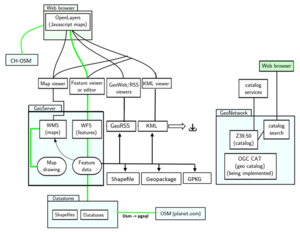
The WMS/WFS flow service offered by CH-OSM provides direct access to vector data layers under QGIS or any other OGC service client environment. These services are referenced in the geocat catalogue, offering a single point of contact, a search interface and metadata consultation. OGC services are available at the following URL:
- WMS 1.3.0: https://ch-osm-services.geodatasolutions.ch/geoserver/ows?service=wms&version=1.3.0&request=GetCapabilities&srsName=EPSG:2056
- WFS 2.0.0: https://ch-osm-services.geodatasolutions.ch/geoserver/ows?service=wfs&version=2.0.0&request=GetCapabilities&srsName=EPSG:2056

CH-OSM Terms of use
You are free to use OGC services (WMS/WFS…) and visualization portals, provided that you respect the following attribution (with the link): © GeoDataSolutions for WMS/WFS (to be added after the © OpenStreetMap contributors[2] related to OpenStreetMap data).
The source code of CH-OSM Portal is published on GitLab under free license MPL-2.0[3].
These various resources are provided free of charge, without any guarantee of service. If you use our services on a regular basis, please send us a short message to inform us. Thank you!
CH-OSM is a trademark of the OpenStreetMap Foundation (OSMF)[4], and is used with their permission. This project is not endorsed by or affiliated with the OpenStreetMap Foundation.
The services of the CH-OSM disseminate thematic data from OpenStreetMap (© OpenStreetMap contributors).
OpenStreetMap data is available under an open licence. Open Data Commons Open Database License (ODbL)[5] from the OpenStreetMap Foundation.
Feedback
Any particular need?
Do you need a new layer with special processing of OpenStreetMap data? Do you need new functionality for our visualisation portal? Do you need a service guarantee, or would you like us to help you set up a customised infrastructure linked to OSM data?
Acknoledgements
Thanks to the communities OpenStreetMap and more broadly, free software, for data, content and tools (osmosis, osm2pgsql, osmium, PostgreSQL/PostGIS, QGIS, GNU/Linux Debian and all the others).
Thanks to Geofabrik for the daily diff files, thanks to Charles Millet whose styles QGIS we provide a good start to produce the SLD styles.
Thanks to GeoAdmin who provide the geocoding Search API REST Services, Matomo for the analytical follow-up.
Many thanks to Magellium and its thematic data service from OSM Magosm from which this site draws heavily.

