CityZen
| CityZen | ||||||||||||||||||||||||||||||||||||||||||||||||||||||||||||||||||||||||||||||||||||||||||||||||||||||||||||||||||||||||||||||||||||
|---|---|---|---|---|---|---|---|---|---|---|---|---|---|---|---|---|---|---|---|---|---|---|---|---|---|---|---|---|---|---|---|---|---|---|---|---|---|---|---|---|---|---|---|---|---|---|---|---|---|---|---|---|---|---|---|---|---|---|---|---|---|---|---|---|---|---|---|---|---|---|---|---|---|---|---|---|---|---|---|---|---|---|---|---|---|---|---|---|---|---|---|---|---|---|---|---|---|---|---|---|---|---|---|---|---|---|---|---|---|---|---|---|---|---|---|---|---|---|---|---|---|---|---|---|---|---|---|---|---|---|---|---|
| Author: | The CityZen community | |||||||||||||||||||||||||||||||||||||||||||||||||||||||||||||||||||||||||||||||||||||||||||||||||||||||||||||||||||||||||||||||||||
| License: | Mozilla Public License 2.0 (free of charge) | |||||||||||||||||||||||||||||||||||||||||||||||||||||||||||||||||||||||||||||||||||||||||||||||||||||||||||||||||||||||||||||||||||
| Platforms: | Android | |||||||||||||||||||||||||||||||||||||||||||||||||||||||||||||||||||||||||||||||||||||||||||||||||||||||||||||||||||||||||||||||||||
| Version: | 1.0.0 (2017-10-11) | |||||||||||||||||||||||||||||||||||||||||||||||||||||||||||||||||||||||||||||||||||||||||||||||||||||||||||||||||||||||||||||||||||
| Languages: | ||||||||||||||||||||||||||||||||||||||||||||||||||||||||||||||||||||||||||||||||||||||||||||||||||||||||||||||||||||||||||||||||||||
| Website: | http://cityzenapp.co | |||||||||||||||||||||||||||||||||||||||||||||||||||||||||||||||||||||||||||||||||||||||||||||||||||||||||||||||||||||||||||||||||||
| Install: | ||||||||||||||||||||||||||||||||||||||||||||||||||||||||||||||||||||||||||||||||||||||||||||||||||||||||||||||||||||||||||||||||||||
| Source code: | https://github.com/CityZenApp | |||||||||||||||||||||||||||||||||||||||||||||||||||||||||||||||||||||||||||||||||||||||||||||||||||||||||||||||||||||||||||||||||||
| Programming languages: | Java | |||||||||||||||||||||||||||||||||||||||||||||||||||||||||||||||||||||||||||||||||||||||||||||||||||||||||||||||||||||||||||||||||||
|
Display, navigation, search, OSM display, submit OSM POI, mark favorites. Active development status since 2017. Keywords: GPS navigator, GPS navigation, navigation system, OpenStreetMap, OSM viewer, map viewer, OSM mapping, outdoor. |
||||||||||||||||||||||||||||||||||||||||||||||||||||||||||||||||||||||||||||||||||||||||||||||||||||||||||||||||||||||||||||||||||||
| ||||||||||||||||||||||||||||||||||||||||||||||||||||||||||||||||||||||||||||||||||||||||||||||||||||||||||||||||||||||||||||||||||||
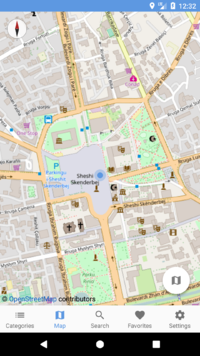
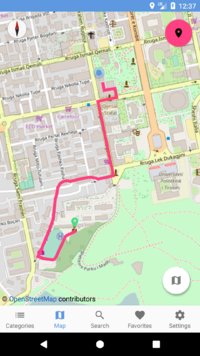
CityZen is an open source Android app that helps you navigate and explore your city easily. With CityZen you find points of interest (POIs) such as ATMs, gas stations, drugstores, mobile phone stores and other interesting services near you. The app shows these POIs based on the location of your smartphone, but it does so by respecting your privacy since we don’t keep your navigation data. The app is licensed in an open source license because we want to engage as many people as possible in improving the app. It is also a way of respecting tools and platforms such as OpenStreetMap that respect our freedoms. If you are an OpenStreetMap contributor you can easily add information to the POIs by editing them inside CityZen.
Download & installation
Users and contributors can download CityZen through F-Droid, an installable catalogue of FOSS (Free and Open Source Software) applications for the Android platform. The F-Droid client makes it easy to browse, install, and keep track of updates on your device.
Language support
Language support in the current v1.0.0 includes only English. However, contributors have already translated the interface into more than 10 other languages, which will be available in the next update.
See status for individual languages and participate in the translation on Hosted Weblate. More information about the translation system can be found in this blog post.
Support the development
If you appreciate the work of the contributors for the project please donate in one of the following ways;
Directly contribute to OpenStreetMap
From within the CityZen application OpenStreetMap contributors will be able to directly amend the global OSM database by;
- Adding new POIs
- Edit existing POIs
Documentation
Categories and data source
- Cafes
- amenity=cafe
- shop=coffee
- Bars/Clubs
- amenity=bar
- amenity=nightclub
- amenity=pub)
- Restaurants
- amenity=restaurant
- amenity=food_court, )
- Fast food
- amenity=fast_food)
- Tourism
- tourism=museum
- tourism=information
- tourism=attraction
- tourism=yes
- historic=monument
- tourism=zoo
- Hotels/Hostels
- building=hotel
- tourism=hotel
- tourism=apartment
- tourism=guest_house
- tourism=hostel
- tourism=motel
- Transportation
- amenity=taxi
- amenity=bus_station
- railway=station
- highway=bus_stop
- railway=tram_stop
- public_transport=station
- railway=subway_entrance
- Gas stations
- amenity=fuel
- shop=fuel
- Pharmacy/Healthcare
- amenity=clinic
- amenity=doctors
- amenity=dentist
- amenity=hospital
- amenity=pharmacy
- shop=herbalist
- healthcare=alternative
- Banks/ATMs/Exchange
- amenity=atm
- amenity=bank
- amenity=bureau_de_change
- Mobile phone store
- shop=mobile_phone
- Markets/Kiosks
- amenity=marketplace
- building=retail
- building=kiosks
- shop=convenience
- shop=kiosks
- shop=supermarket
- shop=general
- shop=variety_store
- shop=tabacco
- Shopping Malls
- shop=department_store
- shop=mall
- Parkings
- amenity=parking
- amenity=parking_space
- building=parking
- Rent a bicycle
- amenity=bicycle_rental
- Rent a car & Care sharing
- amenity=car_rental
- amenity=car_sharing
All the amenities are based on this link: http://wiki.openstreetmap.org/wiki/Map_Features.


