Community Updates/2010-11-29
Community Update from 29 November 2010 to 05 December 2010 (week 2010-48)
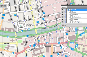
Image Of the Week 2010-48Viewing a map of Dublin City Centre in Adobe Illustrator - SVG file was produced by latest release of Maperitive |
Project Of The Week : Your train station
They are a point in a daily commute of countless people. Utilitarian, they must provide for efficient movement of people in crowds. Seemingly vacant at one minute and then teeming the next, with the hustle and bustle of those determined to get from here to there. The ordinary and repetitious trip of a commuter can lead to blank faces, seeming drones programmed to catch the 7:15 without interaction with others, without emotion.
Yet they have also been the scene of emotional hellos and goodbyes of embraces and tears. An important milestone in a departure or declaration of independence or a the happy relief of a return after a long absence.
The Project of the Week is to map your local train station, bus depot, or other public transit center.
News Of The Week
- OffMaps is "App of the day".
- Merkaartor 0.17-rc3 with Bing imagery now available
- Comlombia making another call for help
- OSMFoundation WG Minutes, Richard Weait wrote a post about the activities of some OSM working groups.
- Frederik Ramm describes in a blog post how the OSM extracts for their Geofabrik download server are made, using OSM tools.
- Adena Schutzberg wrote some interesting thoughts: My Take on Coast Going to Microsoft
- Eric Rodenbeck from Stamen Design took a look at the different categories of scans that get uploaded at Walking Papers. Some of them look like small artwork.
- Oliver Kühn has interviewed Randy Meech from MapQuest about their motivation and commitment to OpenStreetMap.
- New version of the OpenLinkMap is online!
- A new hiking-map for the Netherlands is available [here](http://www.openwandelkaart.nl/).
- MapQuest has now open.MapQuest-websites for Switzerland and the Netherlands too, read their blog announcement.
- New versions of MojoTracker and NaviComputer
- X-Plane 10 will become native OSM support [1] currently you can use an addon: Neat Stuff
- Dr Haklays interview about his compare of OSM data accuracy in UK [2]
- A new mailinglist for Kosovo [3]
Bing imagery available for Tracing
After the thanksgiving week-end, lawers of bing map has announed the terms of use of theres aerial imagery. Between this time, the common editors has started to land support for those imagery.
- Josm through the imagery plugin or the SlippyMap plugin
- Potlatch through the background menu
- Merkaartor as a plugin for the yet to release v0.17 (currently rc3).
Warning : Aerial imagery can be shifted from its origin position. If you forget to correct this in your editor, it can cause problems when editing OSM data. To solve this problem there is a plan to create a central system for automatic correction of this offset.
Potlatch2 published to main OSM site
Potlatch2 the famous OSM editor writen in flash is now available on th main website. If you hold your mouse on the "Modify" tab, you should be able to choose witch yor prefered editor. The rewriting of potlatch has bring lot of improvement and user friendlyness. It's easier to manage tags, backgrounds, relations, undo and saving the changset.
Thanks
Despite the quite week, i had a hand from more people than usual... Thanks everybody, especially (but not only) :
!i!, Pascal and Jonas for the news and Chippy , Stephan75 for corrections and FrViPofm for the useful template!

