Community Updates/2011-06-13
Community Update from 13 June 2011 to 19 June 2011 (week 2011-24)
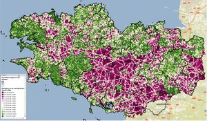
Image Of the Week 2011-24Comparison against IGN's BD Topo maps of Brittany: Green areas mean OSM has more than half the roads mapped. |
Project Of The Week : Museum
As education month continues we turn our sights from schools to museums. These places of wonder and learning range from traditional displays behind glass with descriptive plaques at a museum of natural history to interactive exhibits of levers and pulleys at a science museum. Add your favorite local museums to the map. And don't forget the dinosaurs!
Quick News
- Navigon offers POI add-on packages based on OSM data for their devices
- New scientific research on multimodal trip planners based on OSM
- kothic-js is looking for testers.
- You can help to translate two new video tutorials: Part 1 and Part 2
- OpenStreetMap of Leipzig was featured on the German detective show "Tatort".
- Yahoo imagery will disappear due to shutting down AjaxMaps API on Sep 13.
Events
- Hack the Map
- balrog-kun writes about a mapping party in Koluszki, Poland. Also, kite imagery of that city was collected on a previous meeting.
- User:Kachkaev writes about a mapping party in Penza, Russia: Google translation.
Software
- Walking Papers site is working again.
Other News
OpenId On OSM
You may have already noticed it, but OSM now accepts OpenID logins. You can bind an OpenID account in your profile.
For more info see the OpenID page.
Potlatch V2.2 is out
Potlatch, the 'edit' tab flash editor, has released a new version :
New features include:
- improved vector background layer
- Control-drag an area to select multiple elements
- MapCSS 0.2 support
- Highlight 'merged' tags (e.g. name=High Street;Main Road)
- 'View data' button in the upload progress dialogue, so you can select, copy and paste the changeset XML
- Timed reminders to save your work!
- Lots of bugfixes and little improvements
Statement From NearMap
NearMap is an Australian aerial imagery and location based media company that (amongst other things) creates high resolution aerial imagery over major Australian cities. NearMap aerial imagery is available on CC-BY-SA so a lot of Australian mappers use it to trace for OSM. There were some fears that the move of OSM to ODBL would lead to mass deletion of those data. But this week NearMap finally declared that data derived from their imagery before 17th June 2011 can be regarded as compatible with the new license, but after then the licenses are incompatible.
ODBL : Phase 4 on 19th of June
As you probably know, OSM is changing its license to ODBL . Up until now, users who haven't yet agreed to the new CT were still able to edit. But now the process has reached Phase 4. We are no longer accepting changes from people that do not agree to the ODBL.
Users that haven't yet accepted the new terms or have declined can still accept them by going to their user settings.
Bing Imagery priority ?
Steve Coast, who now works for Bing/Microsoft, asked the community for which regions they would like to have better aerial imagery. He will then pass the suggestions on to the right people.
Thanks
Big thanks to AndiPersti, Zverik and !i! !

