File:GroundTruthContours Overview.png
Jump to navigation
Jump to search


Size of this preview: 800 × 545 pixels. Other resolutions: 320 × 218 pixels | 640 × 436 pixels | 1,024 × 697 pixels | 1,281 × 872 pixels.
Original file (1,281 × 872 pixels, file size: 401 KB, MIME type: image/png)
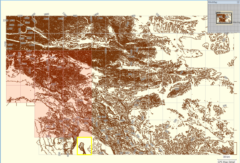
GroundTruth-generated relief contours map for Garmin GPS units. This is a MapSource screenshot of the map tiles.
This is a Featured image, which means that it has been identified as one of the best examples of OpenStreetMap mapping, or that it provides a useful illustration of the OpenStreetMap project. If you know another image of similar quality, you can nominate it on Featured image proposals.
Front-page image for week 16 of 2009 (13–19 Apr.).
- Image descriptions
- Deutsch : Mit GroundTruth erzeugte Konturreliefkarten für Garmin GPS-Geräte. Die Höhendaten stammen aus der Shuttle-Mission SRMT. Das Bild zeigt den Bildschirm von MapSource. Weitere Info gibt es hier.
- English : GroundTruth-generated relief contours map for Garmin GPS units. The elevation data source is SRTM. This is a MapSource screenshot of map tiles. See here for more info.
- italiano : La mappa delle curve di livello per unità GPS Garmin generata da GroundTruth. La fonte dei dati dell'altitudine è SRTM. Questa è una schermata di MapSource delle tile della mappa. Vedere qui per ulteriori informazioni.
- magyar : GroundTruth által generált magassági szintvonalas térkép Garmin GPS egységekhez. A magassági adatok forrása az SRTM. Ez a térképcsempék MapSource-beli képernyőképe. További információ itt.
- português : Mapa de controle de relevo gerado pelo GroundTruth para GPS Garmin. A origem dos dados de elevação é SRTM. Esta é uma captura de tela MapSoruce dos mapas. Veja aqui mais informações.
File history
Click on a date/time to view the file as it appeared at that time.
| Date/Time | Thumbnail | Dimensions | User | Comment | |
|---|---|---|---|---|---|
| current | 20:09, 31 March 2009 | | 1,281 × 872 (401 KB) | Breki (talk | contribs) | GroundTruth-generated relief contours map for Garmin GPS units. This is a MapSource screenshot of the map tiles. |
You cannot overwrite this file.