File:Osm putney cycle.jpg
Osm_putney_cycle.jpg (319 × 500 pixels, file size: 41 KB, MIME type: image/jpeg)
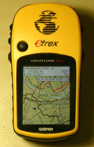
A picture showing a customised version of mkgmap highlighting cycle routes. This image of Putney shows a National cycle route (number 4, as shown) running east-west and various local cycle networks in dark red. You can see the same area on the gravitystorm cycle map. For comparison with the normal styles see Putney on GPS, which was a featured image in February 2007.
- This media file was uploaded by author of the work and its copyright holder.
![]()
![]()
The person who associated a work with this deed has dedicated the work to the public domain by waiving all of his or her rights to the work worldwide under copyright law, including all related and neighboring rights, to the extent allowed by law. You can copy, modify, distribute and perform the work, even for commercial purposes, all without asking permission.

Front-page image on 09 Feb 2008
File history
Click on a date/time to view the file as it appeared at that time.
| Date/Time | Thumbnail | Dimensions | User | Comment | |
|---|---|---|---|---|---|
| current | 17:26, 13 January 2008 | | 319 × 500 (41 KB) | Gravitystorm (talk | contribs) | |
| 13:12, 13 January 2008 |  | 374 × 500 (41 KB) | Gravitystorm (talk | contribs) | A picture showing a customised version of mkgmap highlighting cycle routes. |
You cannot overwrite this file.
File usage
The following 2 pages use this file: