Films
Jump to navigation
Jump to search
This is a list of films and movies that are either about OpenStreetMap or use OpenStreetMap and give credit.
Films about OSM
(None here yet. Why not make one?)
Films that use OSM
While there may certainly be many films that unintentionally use OpenStreetMap as a prop element, or intentionally but neglected to provide credit, some films have intentionally used OSM-derived maps or OSM data in production and provided attribution in the film's end credits.
| Year | Film | Credits OSM? | Use of OSM | Remarks |
|---|---|---|---|---|
| 2015 | Eye in the Sky |  Yes. End credits state "OpenStreetMap - “© OpenStreetMap Contributors”" |
Unconfirmed. Possibly used as rendered intelligence maps of Nairobi, Kenya by UK intelligence agents in the film. | The film also credits a CC-BY-NC-SA project named nairobiGISmaps. |
| 2016 | Inferno |  Yes. End credits state "© OpenStreetMap contributors" |
 OSM is used in a scene (at around 26 min playtime) where WHO agents pursuing Robert Langdon geolocates the IP address of a computer he used in Florence (Firenze), Italy. |
Street and address mentioned are fictional. |
| 2016 | Patriots Day |  Yes. End credits state "Map data © OpenStreetMap contributors www.openstreetmap.org" |
 58m47s Unconfirmed. Possibly used as a basemap of Boston. Location shown: Littleton, Massachusetts 58m47s Unconfirmed. Possibly used as a basemap of Boston. Location shown: Littleton, Massachusetts
|
|
| 2017 | Blade Runner 2049 |  Yes. End credits state “© OPEN STREET MAP CONTRIBUTORS” |
Unconfirmed. Possibly used as basemap of Las Vegas and Los Angeles. | Los Angeles map at 1:34:08. |
| 2018 | The Guilty (Den skyldige) | No. Does not appear in end credits |  Used in the interface of the alarm dispatchers to locate callers. Featured throughout the movie. |
Seems to use the default rendering style. Locations mentioned: Mågevej 26, Næstved real street but fictional number Høker Cafeen really exists fictional "Psykiatrisk Center Nordjælland" at real address Esrumvej 145 Helsingør |
| 2018 | Mission: Impossible – Fallout | No. Does not appear in end credits |  Printed map for planning a heist of a person. Location shown is in the centre of Paris. |
|
| 2020 | All the Bright Places | No |  Used in the end credits (this is the same place shown on osm.org) |
Several printed maps from 1:42:05 for 2 minutes. |
| 2020 | Worth | No | Printed map on a law firm's cork board. Humanitarian OSM rendering style. Location shown: Lower Manhattan, New York | Map at 26:45 and 1:35:40 |
| 2021 | Sophie: A Murder in West Cork | No, nothing when the maps are show, nothing in the end credits. | Netflix uses OSM based geodata to show the locations around the murder.[1] | |
| 2022 | Notre-Dame on Fire | No |  OSM is used in a scene in a screen. Transport OSM rendering style. Location shown: Ile Saint Louis, Paris OSM is used in a scene in a screen. Transport OSM rendering style. Location shown: Ile Saint Louis, Paris
|
Map at 1:18:16 |
| 2024 | Under Paris |  Yes. End credits state "© contributeurs OpenStreetMap - openstreetmaporg/copyright" |
 Location shown is on the Seine river in Paris |
Map at 21 min |
| 2024 | The Bricklayer | Location shown: Πλατεία Εμπορίου | Map at 0:38:48 | |
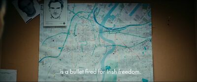
| 2024 | Kneecap |  Old style OSM Carto and old OSM data of Belfast, Northern Ireland, UK |
See also
- TV series – list of TV series that are either about OpenStreetMap or use OpenStreetMap
Notes
- ↑ Contributor b-unicycling recognized this, because she had mapped the area after listening to a podcast about the murder.