Gpsdrive
Jump to navigation
Jump to search
This page describes a historic artifact in the history of OpenStreetMap. It does not reflect the current situation, but instead documents the historical concepts, issues, or ideas.
- Reason for being historic
- This software is not maintained any more. Its website does not exist any more.
| GpsDrive | ||||||||||||||||||||||||||||||||||||||||||||||||||||||||||||||||||||||||||||||||||||||||||||||||||||||||
|---|---|---|---|---|---|---|---|---|---|---|---|---|---|---|---|---|---|---|---|---|---|---|---|---|---|---|---|---|---|---|---|---|---|---|---|---|---|---|---|---|---|---|---|---|---|---|---|---|---|---|---|---|---|---|---|---|---|---|---|---|---|---|---|---|---|---|---|---|---|---|---|---|---|---|---|---|---|---|---|---|---|---|---|---|---|---|---|---|---|---|---|---|---|---|---|---|---|---|---|---|---|---|---|---|
| Authors: | The GpsDrive Development Team, originally by Fritz Ganter | |||||||||||||||||||||||||||||||||||||||||||||||||||||||||||||||||||||||||||||||||||||||||||||||||||||||
| License: | GNU GPL, either v2, or any later version | |||||||||||||||||||||||||||||||||||||||||||||||||||||||||||||||||||||||||||||||||||||||||||||||||||||||
| Platforms: | Linux and macOS | |||||||||||||||||||||||||||||||||||||||||||||||||||||||||||||||||||||||||||||||||||||||||||||||||||||||
| Status: | Broken | |||||||||||||||||||||||||||||||||||||||||||||||||||||||||||||||||||||||||||||||||||||||||||||||||||||||
| Version: | 2.12svn2685 (2012-07-21) | |||||||||||||||||||||||||||||||||||||||||||||||||||||||||||||||||||||||||||||||||||||||||||||||||||||||
| Languages: | English, German, Danish, Greek, Spanish, Estonian, French, Galician, Hungarian, Indonesian, Italian, Japanese, Norwegian Bokmål, Dutch, Punjabi, Romanian, Russian, Slovak, Swedish, Turkish, Vietnamese, and Chinese
| |||||||||||||||||||||||||||||||||||||||||||||||||||||||||||||||||||||||||||||||||||||||||||||||||||||||
| Source code: | https://svn.code.sf.net/p/gpsdrive/code/trunk | |||||||||||||||||||||||||||||||||||||||||||||||||||||||||||||||||||||||||||||||||||||||||||||||||||||||
| Programming language: | C | |||||||||||||||||||||||||||||||||||||||||||||||||||||||||||||||||||||||||||||||||||||||||||||||||||||||
|
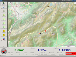
Image: OpenCycleMap downloaded on the fly |
||||||||||||||||||||||||||||||||||||||||||||||||||||||||||||||||||||||||||||||||||||||||||||||||||||||||
| ||||||||||||||||||||||||||||||||||||||||||||||||||||||||||||||||||||||||||||||||||||||||||||||||||||||||
GpsDrive is a free GPS navigation system which works on GNU/Linux and several BSD's including Mac OSX. It is free software licensed under the GPL. The main website is at http://www.gpsdrive.de.
GpsDrive can render OSM data on the fly as you move along the road. Use osm2pgsql to load a planet.osm file into a PostGIS database and make sure that GpsDrive was built with Mapnik support. In the 'Map Control' window enable 'Mapnik mode' and you're away.
If you don't want to go to the trouble of setting up a PostGIS database, you can also download Tiles@Home, OpenCycleMap, and NASA LANDSAT backdrops for your current location, or by using an included script along a chosen route or prior GPX track.
- Grab version 2.11 or newer, preferably build from the latest SVN. (Tiles@Home map projections were fixed after 2.10pre7 was released)


