Indoor=
Jump to navigation
Jump to search
| indoor= | ||||||||||||||||||||||||||||||||||||||||||||||||||||||
|---|---|---|---|---|---|---|---|---|---|---|---|---|---|---|---|---|---|---|---|---|---|---|---|---|---|---|---|---|---|---|---|---|---|---|---|---|---|---|---|---|---|---|---|---|---|---|---|---|---|---|---|---|---|---|
| Author: | User:Francois2 | |||||||||||||||||||||||||||||||||||||||||||||||||||||
| License: | GNU AGPL v3 (free of charge) | |||||||||||||||||||||||||||||||||||||||||||||||||||||
| Platform: | Web | |||||||||||||||||||||||||||||||||||||||||||||||||||||
| Version: | 0.4.0 (2024-04-15) | |||||||||||||||||||||||||||||||||||||||||||||||||||||
| Languages: | ||||||||||||||||||||||||||||||||||||||||||||||||||||||
| Website: | https://indoorequal.org/ | |||||||||||||||||||||||||||||||||||||||||||||||||||||
| Source code: | https://github.com/indoorequal/indoorequal | |||||||||||||||||||||||||||||||||||||||||||||||||||||
|
Display indoor data |
||||||||||||||||||||||||||||||||||||||||||||||||||||||
| ||||||||||||||||||||||||||||||||||||||||||||||||||||||
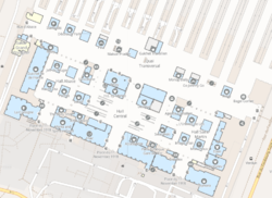
indoor= (indoorequal.org) is a map that displays indoor data.
Supported tags
Only Simple Indoor Tagging is supported. To be able to see the level selector, you must have at least one node/way/relation with an indoor=* tag.
- level=* - mandatory
- repeat_on=*
- indoor=* - level, area, room, corridor, wall
- public_transport=platform
- highway=steps
- All POI from OpenMapTiles + many others
