JA:Tag:power=plant
 |
| 説明 |
|---|
| 発電機によって電力を生産する場所。 |
| OSM Cartoでのレンダリング |

|
| グループ: 電力 |
| 適用できる要素 |
| よく併用されるタグ |
| 状態:承認 |
| ツール |
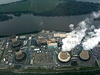
発電所(601-03-01)は、エネルギー(たいていは電気ですが、電気以外のエネルギーも含まれます)を生産する大規模な工業施設です。エネルギー貯蔵施設はhydroelectric pumped storageで表されることが一般的ですが、最近はbattery storage plantsで表されることも増えてきています。
小規模な「分散型」発電施設(屋上のソーラーパネルやマイクロ水力発電、密集して配置された大規模なものをのぞく風力発電機など)は発電所としてタグ付けされるべきではなく、power=generatorのみをタグ付けするべきです。ガイドラインとしては、1 MW以下のものが小規模な発電所とされ、それらは発電所としてタグ付けされるべきではありません。
推奨されるタグ
| キー | 値 | コメント | 推奨 |
|---|---|---|---|
| power | plant |
このエリアを発電所として定義します。 | 必須 |
| name | 名称 | 発電所の名前。 | 推奨 |
| operator | 所有者名 | 発電所を運営している企業などの名前です。 | 推奨 |
| start_date | 日付(YYYY-MM-DD) | 建設が完了した日付です。 |
推奨 |
| landuse | industrial |
柵などで囲われている発電所の多くが産業施設です。 | 柵などで囲われている発電所の場合、周辺地域ごと大きなlanduse=industrialで覆われている場合を除いて、強く推奨。
|
| plant:source | 発電に使用する動力源/燃料 | 発電所内の個々の発電機が使用する動力源(燃料)。複数の燃料を使用している場合はセミコロンで区切ってタグ付けする。(例: plant:source=coal;gas) |
推奨 |
| plant:method | 発電方式 | 発電を行う方式。 | 任意 |
| plant:output:* | 発電所の定格出力 | 大抵の場合は発電事業者が情報を公表しています。タグ付はgenerator:output=*と一致しています。:熱併給発電施設(co-generation plant)の場合は例えばplant:output:electricity=*やplant:output:steam=*キーを使用します。出力の数値を入力するか、出力が不明の場合はyesとタグ付けします。 |
推奨 |
| plant:storage | 蓄電容量 | 発電所が蓄電できるエネルギー量 | 蓄電施設の場合は推奨 |
建設中の発電所
発電所が建設中の場合は、JA:ライフサイクルの接頭辞に則ってPowerタグにconstruction:をつける。(つまりpower=plantをconstruction:power=plantにする)。このライフサイクルの接頭辞はPower以外のタグにはつけてはいけません。柵などで囲われている建設中の発電所は敷地にlanduse=constructionのエリアをマッピングします。
発電所はいずれかの部分が稼働開始するまで建設中タグをつけておく必要があります。(風力発電所では通常、すべての施設が完成するまでに発電を開始します)
建設中の発電所はOpen Infrastructure Mapで見ることができます。
Tagging Guidelines
Power plants can be roughly divided into two types:
- Enclosed power plants, which are facilities on a dedicated piece of land, commonly fenced off. These include conventional coal, gas, and nuclear plants, as well as many solar farms. Offshore wind farms are also included in this category.
- Dispersed power plants, which are spread across an area used for other purposes. Onshore wind farms and hydroelectric plants are common examples, but large rooftop solar farms may also be tagged as a dispersed power plant.
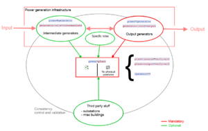
This section provides guidance on how to tag these different types of plants. For more information on the reasoning behind this tagging scheme, see the power generation refinement proposal.
Enclosed power plants

Most conventional power plants consist of a single, fenced, area which is dedicated to the power plant. The power=plant should be tagged as an area ![]() around the power plant perimeter. Within this area, there will normally be one or more
around the power plant perimeter. Within this area, there will normally be one or more generators, and possibly a substation. In some cases a power plant may be split between two or more separate areas. These can be mapped as a multipolygon ![]() .
.
Offshore wind farms are also normally mapped as areas, not as dispersed power plants. The area around the wind farm may have restrictions on navigation, so this area can also be tagged with the appropriate Seamark tags.
Multiple Operators
As discussed on tagging mailing list, power plant areas and perimeters would be pretty hard to map when many different operators share the same location on a generation site.
A simple rule to make the distinguishing between operators is to create a separate area for each one. Two or more power plants would directly be created.
In general, only one company is operating a power plant so if two or more operators are present on a site, we could have two different power plants or two different components for power generation.
In all cases we mustn't map it in a single one area. Each area will have different operator=* values and potentially as many name=*.
The key point is still the ownership of the land occupied by the power plant.
Furthermore and often, room is reserved besides actual power plants for future extensions. This room should be included in the power plant area if it's fenced along with the main production site.
Finally, Relation:multipolygon ![]() doesn't match these operator consideration since operator distinguishing MUST be done.
doesn't match these operator consideration since operator distinguishing MUST be done.
分散型の発電所

Some power plants (such as onshore wind, tidal, hydroelectric and some photovoltaic) may consist of a group of structures (generators, as well as possibly substations, pipelines, or dams) which are spread across a large area. The land between these generators is not fenced, and may be used for agricultural or other purposes.
Each generator (such as a turbine or group of photovoltaic panels) should be tagged as power=generator. These generators are then combined together in a relation with type=site. Relations should only be used when no perimeter surrounds the generators.
Dispersed power plants are not rendered on the standard tile layer, but they are shown on Open Infrastructure Map.
例
This key may be hard to use or understand. Take a look to all those quick examples to find out how it's simpler than it seems ;)
太陽光発電
| 発電所 | タグ付け | 解説 | OSM 参照 |
|---|---|---|---|
| Verrerie solar power plant, France |
|
南フランスにある、日照時に 24MW の電力を生み出す 34ha の太陽光発電所です。航空画像の助けを少し借りて、発電所は単純化のためソーラーパネルのグループとして描かれています。それぞれのソーラーパネルごとに
|
リレーション 3501886 |
洋上風力発電

| 発電所 | タグ付け | 解説 | OSM 参照 |
|---|---|---|---|
| Burbo Bank Offshore Wind Farm, UK |
|
Burbo Bank is an offshore wind farm, which is tagged as an area to allow the appropriate Seamark tags to be used. The individual wind turbines are tagged with |
327949356 |
陸上風力発電

| 発電所 | タグ付け | 解説 | OSM 参照 |
|---|---|---|---|
| Clyde Wind Farm, UK |
|
The Clyde wind farm is a large onshore wind farm consisting of 206 turbines spread around a large area. This dispersed power plant is tagged as a relation. |
6949277 |
化石燃料火力発電
| 発電所 | タグ付け | 解説 | OSM 参照 |
|---|---|---|---|
| Vaires-sur-marne combustion power plant, France |
|
Vaires-sur-Marne used to host a coal power plant which was decommissioned and then destroyed to reuse the site for cleaner combustion turbines.
Currently, 3 combustion turbines of 185 MW each feed the power 225 kV power grid in the Paris area. |
260698234 |
水力発電

For more information on tagging hydroelectric plants, see the approved proposal for hydro power mapping.
| 発電所 | タグ付け | 解説 | OSM 参照 |
|---|---|---|---|
| Hoover Dam(アメリカ ネバダ州) |
|
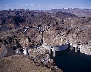
Hoover Dam(旧称Boulder dam)は、アメリカのラスベガス付近に1900年代初頭に建設された有名なダムです。19基の発電機が設置されており、発電された電力は施設内の変電所を介して送電されます。このダムは水道の取水も行っており、周辺地域を潤している。各施設は塀で囲われているわけではないので、リレーションを用いてOSM上で関連付けされています。 | 1652352 |
| Génissiat Dam(フランス) |
|
Genissiat damは、ローヌ川をせき止めて23kmのダム湖を作るために建設された、コンクリートダムです。流れ込み式水力発電が行われており、ダム内に6基の発電機が送水管と接続されて設置されています。河川に対応する水路は、送水管の取水口に対応する専用の方法で流されます。 詳しくは地図を見てください。ヨーロッパにある他の多くの発電所と同じく、Genissiat EICコードがref:EU:ENTSOE_EIC=*で与えられています。
|
80667335 |
| Roselend_Dam(フランス) |
|
Roselend_Damは、アルプス山脈の西側、フランス国内に建設されたダムです。湖の水は60kmもの長大地下水路を通ってLa Bathie地下発電所に送られます。
単一の発電所の地下区画ではなく、関連するすべての地物を独自のリレーションに加える方法でマッピングされています。6基あるフランシスタービンは現在100MWに出力増強を行うために工事中です。発電された電力はAlbertville変電所 |
4500049 |
原子力

| 発電所 | タグ付け | 解説 | OSM 参照 |
|---|---|---|---|
| Gravelines Nuclear power plant, France |
|
Gravelines is the most powerful nuclear electricity generation site in France. 6 units can be found there, with 910 MW output each.
Nuclear reactors are splitted in two map features with |
85203514 |
関連項目
power=generator- A device which converts one form of energy to another, for example, an electrical generator.power=substation- A facility which controls the flow of electricity in a power network with transformers, switchgear or compensators.- Proposed features/Power generation refinement the approved proposal.