Kagi Maps
Jump to navigation
Jump to search
| Kagi Maps | ||||||||||||||||||||||||||||||||||||||||||||||||||||||||||||||||||||||||||
|---|---|---|---|---|---|---|---|---|---|---|---|---|---|---|---|---|---|---|---|---|---|---|---|---|---|---|---|---|---|---|---|---|---|---|---|---|---|---|---|---|---|---|---|---|---|---|---|---|---|---|---|---|---|---|---|---|---|---|---|---|---|---|---|---|---|---|---|---|---|---|---|---|---|---|
| Author: | Kagi Inc. | |||||||||||||||||||||||||||||||||||||||||||||||||||||||||||||||||||||||||
| License: | Proprietary (Subscription) | |||||||||||||||||||||||||||||||||||||||||||||||||||||||||||||||||||||||||
| Platform: | Web | |||||||||||||||||||||||||||||||||||||||||||||||||||||||||||||||||||||||||
| Status: | Active | |||||||||||||||||||||||||||||||||||||||||||||||||||||||||||||||||||||||||
| Language: | English
| |||||||||||||||||||||||||||||||||||||||||||||||||||||||||||||||||||||||||
| Website: | https://kagi.com/maps | |||||||||||||||||||||||||||||||||||||||||||||||||||||||||||||||||||||||||
| Programming language: | JavaScript | |||||||||||||||||||||||||||||||||||||||||||||||||||||||||||||||||||||||||
|
Easily find points of interests, addresses and businesses. |
||||||||||||||||||||||||||||||||||||||||||||||||||||||||||||||||||||||||||
| ||||||||||||||||||||||||||||||||||||||||||||||||||||||||||||||||||||||||||
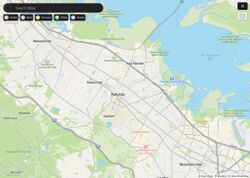
Kagi Maps is a map display provided to subscribers of the Kagi search engine, currently the map is under development by Kagi Inc.
Map Data
Kagi Maps uses data from both Mapbox and OpenStreetMap. Address data and certain specialized 3D buildings comes from Mapbox meanwhile everything else comes from OSM.
Community
There is a feedback forum for the community: https://kagifeedback.org/t/maps
There is also a maps channel in their Discord: https://kagi.com/discord
