Key:abandoned
| Description |
|---|
| A man-made feature abandoned and no longer maintained. Also see abandoned:*. |
| Group: lifecycle |
| Used on these elements |
| Documented values: 11 |
| See also |
|
| Status: in use |
| Tools for this tag |
|
The abandoned=yes tag is used for building=* and other man-made features that have fallen into serious disrepair, appear to be unused, and can not be put back into operation without expensive repair, yet remain identifiable as the same feature.
Use of this tag is discouraged for some features, and where more than one main feature is tagged on the same database element (see One feature, one OSM element).
Consider using abandoned:*=* for features tagged with amenity=*, leisure=*, tourism=* and similar tags which can not be considered to describe the same feature if abandoned.
Also see the tag disused=* and the disused: namespace for features that are not used but are still in a good state of repair, and Comparison of life cycle concepts for alternatives.
How to Map
- A simple feature such as an Tag:man_made=adit which has fallen into decay is tagged with man_made=adit + abandoned=yes.
- Caution: for more complex features with multiple tags it is sometimes unclear which tags are still relevant, and which are not. For example railway=rail + abandoned=yes + highway=track +surface=paved. Does the abandoned tag refer to the railway, the highway or both? Does it also refer to the surface tag? In this case using the abandoned:*=* prefix namespace for specific tags is clearer. Also see One feature, one OSM element - multiple main features should not share the same geometry.
- Some features may still be reasonably tagged with abandoned=yes, for example building=house with abandoned=yes could represent an unoccupied and unmaintained house, which is still clearly a house. It might be repaired and occupied again in the future, or demolished.
- Rarely a feature may be tagged with abandoned=no to specify that it is not abandoned when this would normally be expected, but this is usually unnecessary.
Abandoned=yes vs Abandoned:<key>=* namespace
| Image | Ambiguous tagging | Preferred tagging | Description |
|---|---|---|---|

|
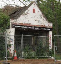
abandoned=yes shop=bicycle building=retail name=The little bike repair shop |
abandoned:shop=bicycle building=retail old_name=The little bike repair shop |
Derelict bike repair shop that can't be brought back into use easily. It's still a retail building, however: most of the roof's still on, and the walls are standing. The tagging reflects its former use, its state of abandonment, and the fact it's still a building. |

|
abandoned=yes highway=unclassified highway=path name=The old road |
abandoned:highway=unclassified abandoned:ref=A6187 highway=path name=The old road |
Subsided former turnpike road in Derbyshire, UK, abandoned in the 1970s as a result of a landslide. Still somewhat passable on foot and by bicycle, so it retains a (new, different) highway tag, and a reference number. |

|
landuse=quarry + abandoned=yes | Abandoned and partially flooded quarry. Note that lifecycle scheme is not used here - that is because quarry describes landscape feature, not company operating there. This is a rare case where abandoned=yes is still recommended. | |

|
railway=rail + abandoned=yes + highway=footway + surface=unpaved | railway=abandoned + highway=footway + surface=unpaved | Abandoned railway - the railway grade, including embankments and cuttings, is still visible, but the rails have been removed and the right-of-way is now used as a footpath . A special tag railway=abandoned is used. |
