Key:cycleway:separation
(Redirected from Key:cycleway:left:separation)
Jump to navigation
Jump to search
| Description |
|---|
| Specifies physical separation (or lack thereof) of cycleways to neighboring traffic users, e.g. to map Protected Bike Lanes. |
| Group: cycleways |
| Used on these elements |
| Requires |
| Status: de facto |
| Tools for this tag |
|
Specifies physical separation (or lack thereof) of cycleways to neighboring traffic users, e.g. to map Protected Bike Lanes. See the proposal for more information and examples on how to use this tagging.
Use cycleway:right:separation=* and/or cycleway:left:separation=* to tag different physical separation materials on either side of the road. cycleway:both:separation=* is used about as often as cycleway:separation=* to tag both sides of the road.
Typical values
Multiple values can be combined with semicolons.
- no – no physical separation.
- bollard – solid bollards that could stop a car.
- flex_post – plastic traffic posts that a car could run over.
- vertical_panel – larger or smaller traffic panels, sometimes only for temporary separation.
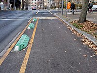
- bump – small bumps/guide curbs/separation kerbs/armadillos mounted on the ground to make it more difficult for vehicles to pass over.
- planter – flowerpot or box for plants.
- kerb – common on the right side of cycle lanes or on the left side of cycle tracks.
- greenery – a green stripe (often with grass).
- hedge – a hedge or dense scrub - in contrast to a green stripe it's rather difficult to traverse.
- tree_row – a line of trees.
