Key:landuse:secondary
| Description |
|---|
| Additional landuse values for a landuse area |
| Group: landuse |
| Used on these elements |
| Useful combination |
|
| See also |
|
| Status: proposed |
| Tools for this tag |
|
Use the tag landuse:secondary=* in addition to landuse=* to add additional landuse values to an area. Areas where this applies are often but not limited found in urban areas.
Status
This tag was proposed[1] but rejected. Nonetheless, there was some support hence this page is created to documented the usage.
Tagging
Draw an area and use landuse=* to indicate the main use of an area. Next, use landuse:secondary=* (or values like teriary for even more values) to indicate additional landuse. Additionally, all sub tags that can be applied to landuse can be used as normal like name=* or residential=* without namespacing.
The detail on which the landuse is mapped is up to the mapper. People can map landuse for a large area, per building block or per building (for example in a street with mixed landuse use and where the mapper wants to micromap the landuse). Note that for if example within a residential area (lets say covering a city (block) or neighbourhood) there are a few single/ small businesses, dual tagging the retail/commercial use should not be used. This is not in proportion and then retail and commercial can be added to a lot of landuse areas. It is then preferred to split up the area and map it in more detail.
When not to use this tag
Tagging additional landuse should not be used if a value already implies the presence of another landuse value by definition. For example landuse=farmyard by definition already includes a house. There is no need to draw an area of landuse=farmyard and use dual tagging to add landuse=residential for the house.
Another example is landuse=construction. Use construction=* and not landuse:secondary=* to indicate the type of landuse that is beeing built.
Examples
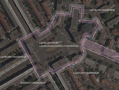
Find below an example.
