Key:narrow
Jump to navigation
Jump to search
 |
| Description |
|---|
| Relative indication that a way gets narrower. |
| Group: properties |
| Used on these elements |
| Useful combination |
| See also |
| Status: approved |
| Tools for this tag |
|
Sometimes, highways or waterways get narrower for a brief period of time, such as "under" a long-removed bridge. They can also be narrow because of parked cars. It's useful, when reading a map, to know that this is coming. It's also a handy navigational aid.
How to map
Add narrow=yes to the part of the way that gets narrower.
Rendering
Temporary narrowing of blue line in case of waterways
Examples
| Photo | Tags | Remarks |
|---|---|---|

|
narrow=yes
|
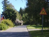
A residential road with a relative indication that it's getting narrower. |

|
narrow=yes
|
The cars parked on both sides of an otherwise large enough road render it narrow. |
See also
hazard=road_narrows- A place where the road narrows immediately following the signwidth=*- specify the width of a waylanes=*- the physical amount of travel lanes on a way, may decrease on a narrow sectionpriority=*- marks which direction has the right of way when two vehicles meet and are unable to pass each othertraffic_calming=choker,traffic_calming=chicane- a point along a road, that is narrowed/sharply curved, deliberately designed to slow down or discourage motor vehicle traffic- Approved features/Narrows