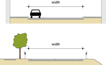
Key:width
| Description |
|---|
| The width of a feature. If not specified, the default unit is the metre. |
| Group: properties |
| Used on these elements |
| Useful combination |
|
| See also |
| Status: de facto |
| Tools for this tag |
|
The key width describes the actual width of a way or other feature. By default, values will be interpreted as metres. To reduce the risk of misunderstandings, or if the width should be specified in a different unit, the unit can be added to the end of the value, separated by a space (see #Examples). The value should always use the dot as decimal separator, if needed.
The source of the width information can be specified by source:width=*.
Examples
| Width | Tagging | Remark |
|---|---|---|
| Two metres | width=2 | Alternatively width=2 m could be used. But this is far less common. |
| 0.6 miles | width=0.6 mi | Please note the dot as decimal separator! |
| 16 feet and 3 inches | width=16'3" | Use a typewriter apostrophe character after the feet value and a typewriter double-quote character after the inches value. Spaces are not permitted. |
Common mistakes
Legally restricted width
Do not confuse the specification of the actual width with the specification (of a legal restriction) of a maximum permissible width of vehicles via maxwidth=*.
Descriptive values
It is discouraged to specify values as, e.g., width=narrow or similar. See therefore this proposal.
Estimated values
If the width couldn't be exactly determined or is estimated, use the key est_width=* instead.
Incorrect values
Often the values themselves are not specified correctly. The following table contains examples of incorrect tags and their correct notation.
| Incorrect | Explanation | Correct |
|---|---|---|
width=2km
|
The space between value and unit is missing. | width=2 km |
width=0,6
|
The comma is used as wrong decimal separator. | width=0.6 |
width=12' 6"
|
There should not be a space between feet and inches. | width=12'6" |
Width of doors and entrances
The width of a door=* or entrance=* is the smallest opening when the door is fully opened. This is typically measured over the floor between the two sides of the chambranle, unless another part is smaller.
Width of streets
The width=* tag for streets describes the width of the carriageway from kerb to kerb or edge to edge. This includes cycle lanes and any parking lanes if they are on the street but excludes anything beyond the kerb/edge like sidewalks, cycle paths or street side parking. However, for a long time there was no consensus on this and no clear definition, so data consumers should expect some fuzziness when interpreting this tag for streets.
There are some tags to specify the width of individual elements that compromise a street:
- width:carriageway=* is a more explicit tag to indicate the width of the entire carriageway, i.e. kerb to kerb or edge to edge. Nowadays, the meaning can be considered identical to that of width=*, so simply width=* should be preferred instead.
- cycleway:side:width and sidewalk:side:width are the width of cycle paths and sidewalks if they are mapped on the roadway
- parking:left=*/parking:right=*/parking:both:width=* is the width of parking lanes in context of street parking (Note: In many places, depending on the orientation of the vehicles and the local norms, parking lanes have a default width that doesn't need to be mapped explicitly, but there may be variations from this like very narrow or very wide parking spaces.)
- shoulder:width=* is the width of shoulders
- width:lanes=* is the width of different lanes
The effective usable width of the carriageway (the width of the area on which vehicles move in flowing traffic) can be determined either from width=* minus any existing parking lanes (see the street parking scheme) or from the use of width:lanes. width:effective=* is rarely used to specify this explicitly. However, with or without markings, relocated vehicles, etc. it is unclear where the exact limit for measuring the effective width is located.
Consider using est_width=* if you can only estimate the width of a road.
Methods to map width
With JOSM
It is possible to create a way in JOSM across the width of the feature, and this will show the estimated width at the bottom of the screen, see the figure for a demonstration:
In this example, the red line across the road is a way which was created from kerb to kerb (the carriageway is asphalt and the kerbs are concrete), and JOSM estimated this as 11.64 meters.
With StreetComplete or StreetMeasure
Since version v41 StreetComplete can measure distances using your camera. This is only available on some devices. In v51, the measuring functionality has been split off into a separate app, StreetMeasure.
Manual
The most accurate way to measure distances is using a tape measure or similar. There are also laser distance measure devices you can buy. You can also make use of a measurement app on your phone, but in that case, StreetMeasure is recommended if using Android.
When the surface is paving stones, you can also measure a single stone and count the stones. There may be regional variations which stones are commonly used, but a lot of paving stones use the same standardized sizes (e.g. rectangular 20×10 cm is a common one, as is square 40×40 cm).
See also
- Overview of possible units
- Specification of the height via height=*
- Specification of the length via length=*
- Specification of distance via distance=*
- Specification of the maximum permissible width of vehicles via maxwidth=*
- Approved proposal to make the value narrow obsolete.


