Key:position
| Description |
|---|
| Relative distance between the feature and another feature which the first points toward |
| Group: properties |
| Used on these elements |
| Useful combination |
|
| Status: in use |
| Tools for this tag |
|
It's usual to find surface markers marker=* indicating the presence of underground or at least hidden features (like an underground fire hydrant, see examples) next to it. Distances may be written on that marker showing how to find the hidden feature to allow operators or users, when they are facing the marker, to find what markers refers to.
This key is intended to describe the values read on ground from signs used by utilities. It may help to check data consistency by looking for expected feature at the given position.
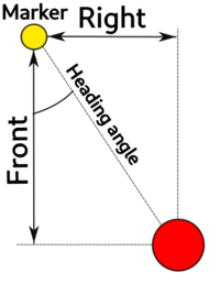
It is possible to put a list as value of position=* key with following order : <left>;<right>;<distance>;<heading> - this format is commonly used on utility markers in France and some other countries.
- <left> ; <right>: When facing the marker, distance in meters you must travel to the side (left or right) to then head towards the marked feature. If <left> is a positive value, then <right> will always be "0".
- <distance>: When facing the marker, distance in meters you must travel forward to reach the marked feature.
- <heading>: The direction the marker is facing in degrees (0 .. 360). It may be measured by a compass, but is usually also stored as EXIF value in pictures taken by modern smartphones (don't forget to subtract 180°).
It's also possible to use simpler values with following keys
- position:left=* : When facing the marker, left distance towards the marked feature
- position:right=* : When facing the marker, right distance towards the marked feature
- position:distance=* : Front distance between the marker and marked feature
- position:heading=* : Angle between the front face of marker and a line towards the marked feature
Examples
| Photo | Location | Tagging | Note |
|---|---|---|---|
| France | utility=hydrant position:distance=6.40 |
Those plates are currently rolled out by Eau de Paris and gives several information about a near hydrant installed at stated distances from the marker. The hydrant is fed by water main of given diameter. The hydrant is located 6.4 meters directly in front of the sign (so behind you if you look at the marker on the picture). | |
| Austria, Germany | utility=hydrant position:distance=8.4 position:left=1.1 |
Fire hydrant markers as used in Germany. Indication of distance, left and right are clearly displayed. From the marker, you must move left 1.1 meters and then walk straight forward 8.4 meters to reach the hydrant. |


