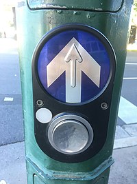
Key:traffic_signals:arrow
| Description |
|---|
| Indicates the presence of a tactile wayfinding arrow. |
| Group: accessibility |
| Used on these elements |
| Requires |
|
| Useful combination |
|
| Status: in use |
| Tools for this tag |
|
This key indicates whether a signal-controlled pedestrian crossing features a tactile arrow indicating to a visually impaired person the direction of the pedestrian crossing. The tactile arrow is typically located on or near the pedestrian call button.
How to map
The highway=crossing ![]() or highway=footway footway=crossing
or highway=footway footway=crossing ![]() should first have a crossing=traffic_signals and / or crossing:signals=yes tag to indicate that the pedestrian crossing is signal-controlled.
It should also be tagged with button_operated=yes to indicate whether there is a pedestrian call button.
Tag it with one of the following values to indicate whether there is a tactile arrow on the device housing the call button, which may be a pole or a control box:
should first have a crossing=traffic_signals and / or crossing:signals=yes tag to indicate that the pedestrian crossing is signal-controlled.
It should also be tagged with button_operated=yes to indicate whether there is a pedestrian call button.
Tag it with one of the following values to indicate whether there is a tactile arrow on the device housing the call button, which may be a pole or a control box:
- traffic_signals:arrow=no – no tactile arrow present
- traffic_signals:arrow=yes – tactile arrow present
Examples
Rendering
Planned to be rendered on Look and Listen Map.
See also
- OSM for the blind
- highway=traffic signals (for vehicular traffic)
- traffic_signals:vibration=yes/no
- traffic_signals:sound=yes/no
- traffic_signals:minimap=yes/no
External links
- Accessible Pedestrian Signals: Tactile arrow – detailed usage notes for the United States


