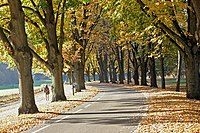
Key:tree_lined
| Description |
|---|
| Indicates that trees have been deliberately placed along a feature. |
| Group: properties |
| Used on these elements |
| Useful combination |
| See also |
| Status: de facto |
| Tools for this tag |
|
This is a property to indicate that a feature is lined with trees along its length. The tag is typically used in conjunction with highways or waterways, i.e. linear features. It is unclear whether the tag should be used on polygons.
This property implies that the trees "belong" to the feature, in the sense that they have been purposefully planted for flanking the feature (common examples are lines of trees along avenues). It also commonly implies that the trees are planted in a planned order and structure — e.g. same size and type of trees (or sometimes a limited number of different species), equally distanced or distributed in a rhythmic pattern.
Do not use the tag when there are trees that simply happen to be close to the feature but were not placed there specifically to flank the feature.
How to map
Add the tag to the feature. Possible values are:
| Value | Description |
|---|---|
| both | The feature has trees on both sides. |
| right | The feature has trees on the right side. |
| left | The feature has trees on the left side. |
| no | There are no trees along the feature. |
| yes | There are trees on either one or both sides of the feature. As this could mean any of the first 3 values above, you should use one of those values instead. |
| separate | There are trees along this feature that are mapped separately as separate natural=tree or natural=tree_row. Consider the more specific tags below. |
When trees that flank a feature are mapped separately, the tree_lined=separate tag can be used to indicate this on the feature itself, but it doesn't make it clear whether the trees exist on both or just on one side. Therefore, it's best to use the more specific keys tree_lined:both=*, tree_lined:left=*, and tree_lined:right=* to provide more specific information, as in the examples below:
| Example | Description |
|---|---|
| tree_lined:both=separate | There are two rows of trees mapped separately on both sides of the feature. |
| tree_lined:right=separate + tree_lined:left=no | There is a row of trees mapped separately on the right side of the road, and no trees on the left side. |
| tree_lined:right=separate + tree_lined:left=yes | There is a row of trees mapped separately on the right side of the road, and a row of trees on the left side which is not mapped separately. |
Possible tagging mistakes
See also
- natural=tree_row — an explicitly mapped row of trees.
- denotation=avenue — to indicate trees (either as nodes or as a tree_row way) that are placed alongside a road.
- natural=tree — an individual tree.
alley=left/right/both- for each road-segment with trees, additional tree=numbers (this is a misnomer which likely stems from the similar German word “Allee” for a tree lined road, do not use it)
