Key:wetland
Jump to navigation
Jump to search
| Description |
|---|
| Type of wetland. |
| Group: natural |
| Used on these elements |
| Documented values: 13 |
| Requires |
| Status: approved |
| Tools for this tag |
|
This key is used to refine elements tagged with natural=wetland. Main wetland types include swamps, marshes, bogs and fens. Sub-types include mangrove, carr, pocosin, and varzea.
- See also wetland on Wikipedia.
Tagging
| Tag | Rendering | Description | Picture |
|---|---|---|---|
| Open habitats | |||
| wetland=marsh | 
|
Marshes are periodically saturated, flooded, or ponded with water and characterized by herbaceous (non-woody) vegetation adapted to wet soil conditions. Use this for non-tidal marshes and wetland=saltmarsh for tidal marshes. | 
|
| wetland=reedbed | 
|
Reed-bed, an inundated area dominated by certain tall non-woody plants (reeds, bulrushes). | 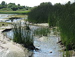
|
| wetland=saltmarsh | 
|
Coastal marshes, exposed to tidal inundation with sea water, therefore characterized by herbaceous plants with special adaptations to saline environments. Ditches/channels in these marshes should be tagged with waterway=ditch. Grid-like ditches in saltmarshes were often dug to drain standing water pools in the marsh and therefore eliminate salt marsh mosquitoes. [1] | 
|
| wetland=tidalflat | 
|
Coastal wetlands that form in intertidal areas where sediments have been deposited by tides or rivers. In this kind of wetlands you will find a lot of birds, crabs, mollusks.
See mudflat on Wikipedia. Don't use this wetland for sand or rocks visible at low tide because there is no life here. Use natural=sand/shoal/bare_rock/rock + tidal=yes instead. |

|
| wetland=wet_meadow | 
|
A semi-wetland meadow which is saturated with water throughout much of the year. Can be caused by poor drainage or the receipt of large amounts of rainwater or melted snow or in riparian zones. | 
|
| Forested habitats | |||
| wetland=swamp | 
|
An area of waterlogged forest, with dense vegetation. | 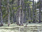
|
| wetland=mangrove | 
|
Mangrove swamps are coastal wetlands characterized by salt-tolerant trees, shrubs, and other plants growing in brackish to saline tidal waters | 
|
| Bog | |||
| wetland=bog | 
|
Bogs are peat-filled depressions that receive their water and nutrients from rainfall. They are frequently covered in shrubs rooted in the sphagnum moss and peat. | 
|
| wetland=fen | 
|
Fens are groundwater-fed peatforming wetlands covered by grasses, sedges, reeds, and wildflowers. | 
|
| wetland=string_bog | 
|
A string bog or strong mire is a bog consisting of slightly elevated ridges and islands, with woody plants, alternating with flat, wet sedge mat areas. String bogs occur on slightly sloping surfaces, with the ridges at right angles to the direction of water flow. | 
|
Citations
- ↑ “Tidal Wetlands”. Long Island Sound Study. Retrieved 11 December 2014.
