Tag:wetland=reedbed
Jump to navigation
Jump to search
| Description |
|---|
| An inundated area dominated by certain tall non-woody plants (reeds, bulrushes, cattail). |
| Rendering in OSM Carto |

|
| Group: natural |
| Used on these elements |
| Requires |
| Status: approved |
| Tools for this tag |
|
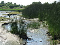
A ![]() reed bed is a flooded area dominated by some tall non-woody plants such as reeds, bulrushes and Phragmites. wetland=reedbed is distinguished from wetland=marsh by their tall vegetation that makes them difficult to walk through. This tag is used for both natural and constructed reed beds.
reed bed is a flooded area dominated by some tall non-woody plants such as reeds, bulrushes and Phragmites. wetland=reedbed is distinguished from wetland=marsh by their tall vegetation that makes them difficult to walk through. This tag is used for both natural and constructed reed beds.
How to map
Draw the shape of the area, then tag with natural=wetland and wetland=reedbed.
This could be included as an inner or outer part of a multipolygon relation if intermixed with dry land, other types of wetlands, or open water areas.
Similar tags
- wetland=marsh - General tag for wetlands with non-woody vegetation
- wetland=wet_meadow - Meadow that is saturated with water much of the year
