Louisville, Kentucky/Building Outlines Import
Work Complete
| Data import is COMPLETE! Track our import progress here and help out at task tracker (link offline now): http://tasks.openstreetmap.us/job/50 |
Note that Task Manager US had a massive server failure and all data for all projects was lost. Version 2 is now live, but with no data.
Code for America Slide Deck - Post-mortum presentation at national conference
We have created a detailed discussion on the OSM mailing lists (imports-us@ and imports@) in January and February of 2015. The lists seem to agree on our direction and process, following in the footsteps of NOLA's work.
This process will be in accordance with OSM's Import Guidelines.
How to get involved
| Everything that mappers need to know to get involved should be found in our live Contributor Guide. |
Read about our recap and progress on our website!
Everything else found below on this page is background/technical information on the import which was prepared while this project was under consideration. It is not necessary to read on unless you want to learn more about how this project began.
Historic Overview
Louisville's American Printing House for the Blind is an international institution. Using open data, they have created an app that helps blind and visually impaired people navigate cities safely!
APH uses Open Street Map (OSM) standardized layer data to import into their app. They load data into OSM from open data portals that have an open data license. The app uses audio to announce important locations as visually impaired people walk around.
Right now they either don't have, or have to pay for, good data about buildings, street addresses, parcels, sewer drains, manholes, power poles, parking meters, and street crossings.
The app is called Nearby Explorer and is a $99 Andoid App.
With the data they can 1) improve walking and driving safety of visually impaired people, 2) possibly charge less for the app, 3) serve as a model for other US city's open data, thereby increasing their coverage area.
The CDA has volunteered to help APH work with OSM to import the data properly, a process that is both technical and bureaucratic (mass data imports need much coordination with the OSM community). We also want to host Code for America's national Code Across hackathon February 20-22 at the APH facilities and make it the focus of Louisville's Code Across event.
Additionally, if successful, APH employees are happy to speak this summer at the national Code for America Summit and share this great open data success for APH, Louisville, and the CDA!
About the data
The City of Louisville Metro provides us with a public domain shapefile with high-quality building outlines (412,375 buildings, based on imagery updated in 2012, due for an update in 2015) and a shapefile of addresses (398,982 points, commercial and residential, updated daily, through January 2015).
License
According to the Data Policy page on data.louisvilleky.gov, the data is licensed free and without restriction. (Public domain)
"Data available through Louisville’s Open Data Portal is offered free and without restriction."
Data to Import
Building Outlines
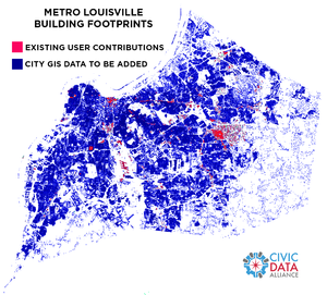
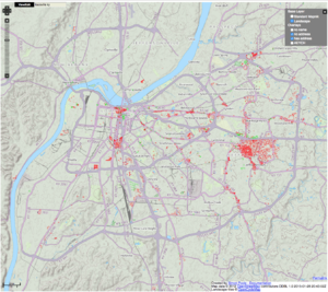
412,375 official buildings vs 5,800 existing OSM user contributions (<1.5%).
Street Addresses
- Source Data: ftp://ftp.lojic.org/pub/federal/
Bright green = address mapped. Bright red = no address mapped. Everything else has no address in OSM. See http://qa.poole.ch/ for details.
398,982 official address point data vs almost no existing data.
Buildings Plus Addresses
Our solution might be to load buildings with address data associated with it already, where possible.
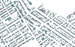
Sample of address data overlayed on building data. Note that addresses are centered over the center of the building footprint, if there is a building. Then they are centered on the parcel (parcels not shown in this image). In the case of condos, they are stacked and slightly offset.
Data Analysis
Qualitative analysis manually comparing existing OSM data to city data in neighborhoods (Jtown, Highlands, Downtown) well known by contributers shows that the address and building data is of high quality. We will still be examining things closely during the import but we are confident that this will be a useful addition to the OSM community.
Tagging
- building = yes
If building only contains one address, the following will be added to the area.
- addr:housenumber = HOUSE_NUMB
- addr:street = DIR (expanded: N->North) + STREET + TYPE (expanded: ST->Street)
- addr:state = KY or IN, since both are in the coverage area
- addr:city = Louisville has 50 or so smaller 2nd-6th class independent cities within the county, so these will be added.
- addr:postcode = 5 digit post code
In the case with multiple addresses in different locations within the same building footprint, these tags will go on separate nodes with unit numbers:
- addr:unit = for individual address points, all placed withing building footprints. Eg, 1, 201, C.
Every building also has a special unique identifier:
- lojic:bgnum = Numerical ID, eg, 246958.
This is used to later add height data to buildings when we get that sorted, to allow the supporting data organization (LOJIC) grab citizen OSM edits an import changes into their system, and also help with future updates.
Reconciliation with existing buildings in OSM
There are not a lot of buildings already in OSM for Louisville, KY. As of January 2014 there are less than 5,800, which is about 1.5% of the total. Where there is overlap, we will preserver the OSM edits, unless the city data is obviously better on a case by case basis.
Conflation with existing addresses in OSM
398,982 official address point data vs almost no existing data in OSM. We will manually compare any overlap and choose the best address locations based on our conflation with the building data and local knowledge.
Participants
- Michael Schnuerle: Project lead. longtime local mapper and resident. Co-captain of Louisville's Code for America Brigade.
- American Printing House for the Blind: APH tech team helping with data load. APH is the reason we want to do this project!
- Civic Data Alliance: OSM account for Civic Data Alliance (CDA)
- Jeff McAdams: Active local OSM editor
- Metro Mapper: Local mapping website and OSM editor
- Patrick Smith Co-captain of Louisville's Code for America Brigade.
- Chris Harrell: CDA member
- Brian Herbert: Ushahidi Guy
Process
User accounts
In accordance with Import Guidelines, each uploader will use a separate user account specifically for this import. The user name will follow the pattern: <regularusername>_louisvilleimport
Task Manager
Here is where you can import the data area by area: http://tasks.openstreetmap.us/job/50
Workflow
See the Contributor Guide for all the details!
Resources
We're starting to collect info from previous imports that may be helpful to our volunteers:
- Video: How to set up JOSM to integrate with task manager
- Video: creating an account for import
- How to review and upload data from .osm files using Potlatch 2
The folks who ran the NYC building import used a very similar process, and have a nice step-by-step video guide for getting started:
- OSM NYC Building and Address Import (playlist of several ~2 minute video screencasts) (one note: we will have a different OSM tasking manager URL than in the NYC case. Otherwise the same steps should work fine.)
QA tools:
Source Code
This is based on work from the DC and NYC and NOLA building imports, thanks to the folks who made that possible.


