MapTool
| MapTool | ||||||||||||||||||||||||||||||||||||||||||||||||||||||||||||||||||||||||||||||||||||||||||||||||||||||||
|---|---|---|---|---|---|---|---|---|---|---|---|---|---|---|---|---|---|---|---|---|---|---|---|---|---|---|---|---|---|---|---|---|---|---|---|---|---|---|---|---|---|---|---|---|---|---|---|---|---|---|---|---|---|---|---|---|---|---|---|---|---|---|---|---|---|---|---|---|---|---|---|---|---|---|---|---|---|---|---|---|---|---|---|---|---|---|---|---|---|---|---|---|---|---|---|---|---|---|---|---|---|---|---|---|
| Author: | MetaViewSoft | |||||||||||||||||||||||||||||||||||||||||||||||||||||||||||||||||||||||||||||||||||||||||||||||||||||||
| License: | (free of charge) | |||||||||||||||||||||||||||||||||||||||||||||||||||||||||||||||||||||||||||||||||||||||||||||||||||||||
| Platform: | WebOS | |||||||||||||||||||||||||||||||||||||||||||||||||||||||||||||||||||||||||||||||||||||||||||||||||||||||
| Version: | 4.7.0 | |||||||||||||||||||||||||||||||||||||||||||||||||||||||||||||||||||||||||||||||||||||||||||||||||||||||
| Language: | English
| |||||||||||||||||||||||||||||||||||||||||||||||||||||||||||||||||||||||||||||||||||||||||||||||||||||||
| Website: | http://metaviewsoft.de/wordpress/?p=318 | |||||||||||||||||||||||||||||||||||||||||||||||||||||||||||||||||||||||||||||||||||||||||||||||||||||||
| ||||||||||||||||||||||||||||||||||||||||||||||||||||||||||||||||||||||||||||||||||||||||||||||||||||||||
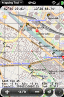
MapTool is a map-viewing program for the WebOS platform (Palm Pre, Palm Pixi). It downloads map tiles from the main tile server by default, but has options to use other tile servers (including Osmarender and OpenCycleMap) built in, as well as an "offline" option to use pre-downloaded tiles.
It can record tracks and either send them in GPX format via email or (if the FileMgr program is also installed) save GPX files to the phone's internal storage. Previously-recorded tracks can also be displayed on the map. Waypoint recording is not supported.
The program can send its location via email or SMS.
Targets can be recorded (e.g. for geocaching) and the program will show the direction and distance to a selected target.
In addition to the map, the screen displays the current latitude and longitude, altitude, elevation, HDOP, and the current position of the sun (to serve as a sun compass).
A paid Pro version exists, some additional features Pro version:
- map caching
- mass-download option for offline use
- full screen view
- photo layer over map with images from Flickr and Panoramio
- separate folders for each map provider
