Osm2go
- For discontinued OSM2go server, see Osm2go-server.
- For 3D web app, see OSM go.
- For 2D mobile app, see Osm Go!.
| OSM2Go | ||||||||||||||||||||||||||||||||||||||||||||||||||||||||||||||||||||||||||||||||||||||||||||||||||||||||||||||||||||||||||||||||
|---|---|---|---|---|---|---|---|---|---|---|---|---|---|---|---|---|---|---|---|---|---|---|---|---|---|---|---|---|---|---|---|---|---|---|---|---|---|---|---|---|---|---|---|---|---|---|---|---|---|---|---|---|---|---|---|---|---|---|---|---|---|---|---|---|---|---|---|---|---|---|---|---|---|---|---|---|---|---|---|---|---|---|---|---|---|---|---|---|---|---|---|---|---|---|---|---|---|---|---|---|---|---|---|---|---|---|---|---|---|---|---|---|---|---|---|---|---|---|---|---|---|---|---|---|---|---|---|---|
| Authors: | Till Harbaum, Rolf Eike Beer | |||||||||||||||||||||||||||||||||||||||||||||||||||||||||||||||||||||||||||||||||||||||||||||||||||||||||||||||||||||||||||||||
| License: | GNU GPL v3 | |||||||||||||||||||||||||||||||||||||||||||||||||||||||||||||||||||||||||||||||||||||||||||||||||||||||||||||||||||||||||||||||
| Platforms: | Linux and Maemo | |||||||||||||||||||||||||||||||||||||||||||||||||||||||||||||||||||||||||||||||||||||||||||||||||||||||||||||||||||||||||||||||
| Version: | 0.9.17 (2020-12-06) | |||||||||||||||||||||||||||||||||||||||||||||||||||||||||||||||||||||||||||||||||||||||||||||||||||||||||||||||||||||||||||||||
| Language: | English
| |||||||||||||||||||||||||||||||||||||||||||||||||||||||||||||||||||||||||||||||||||||||||||||||||||||||||||||||||||||||||||||||
| Website: | http://www.harbaum.org/till/maemo/index.shtml#osm2go | |||||||||||||||||||||||||||||||||||||||||||||||||||||||||||||||||||||||||||||||||||||||||||||||||||||||||||||||||||||||||||||||
| Source code: | https://github.com/osm2go/osm2go | |||||||||||||||||||||||||||||||||||||||||||||||||||||||||||||||||||||||||||||||||||||||||||||||||||||||||||||||||||||||||||||||
| Programming languages: | C++ and C | |||||||||||||||||||||||||||||||||||||||||||||||||||||||||||||||||||||||||||||||||||||||||||||||||||||||||||||||||||||||||||||||
|
Mobile, touchscreen based editor |
||||||||||||||||||||||||||||||||||||||||||||||||||||||||||||||||||||||||||||||||||||||||||||||||||||||||||||||||||||||||||||||||
| ||||||||||||||||||||||||||||||||||||||||||||||||||||||||||||||||||||||||||||||||||||||||||||||||||||||||||||||||||||||||||||||||
What is OSM2Go?
OSM2Go is an OSM editor designed to run on small devices. It's written in GTK+/C and currently runs on GTK equipped Unix and Linux desktops and the GTK/Hildon-based Nokia Internet tablets N900 (running the Maemo platform over Linux) for which it's primarily been designed. Older versions also supported the N800 and N810 devices.
OSM2Go is currently maintained by Rolf Eike Beer, download latest source code from GitHub.
64 bit identifiers
Versions before 0.8.3 have several bugs in support of 64-bit Identifiers. Later versions should have this fixed.
Installation
Nokia Internet Tablets
Binary packages are provided for N900 on GitHub. They require a more recent version of OpenSSL as the one that is installed in Maemo, which is also provided onGitHub. It can be installed in parallel with the normal one, so no disruptions of other software should happen.
The stores for N800/N810/N900 still have packages of OSM2go, but they are heavily outdated and will cause data corruption with 64 bit ids.
Installation from source
This is documented in the GitHub wiki.
Features
Current featureset includes:
- Managing multiple mapping projects.
- Adding, moving and deletion of ways and nodes and editing their tags.
- JOSM-style presets for speedy tagging.
- Import GPS traces or Live GPS trace for GPS-enabled devices
- WMS server support: NASA satellite imagery
- Limited relation support
- Upload and download changes to the OSM servers!
Screenshots
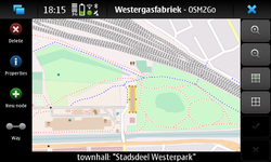
Version 0.9.x on N900
Version 0.7.23 on N900
Version 0.6 on N8x0
The exact version and device is unknown.
Usage
The typical usage pattern of OSM2Go is probably like this:
- Set up a project with the desired bounds
- download the project data from OSM
- go around mapping
- upload the edited data back to OSM
Setting up a project
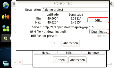
On startup the tool show the project selection. Use the "New..."-button in the lower left corner to set up a new project. First add a name and oIf this is not displayed use Menu --> Project --> Open... and click the Add button. In the next screen enter a project description. Then continue by clicking the "Edit..."-button on the right.
Up to four tabs offer you different approaches to define the area you want to download and edit:
- Get extends from internal map. This is the easiest approach and should be used by beginners.
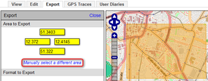
- Use min/max latitude and longitude to define a rectangular box. If you have a desktop computer nearby you can use the Export-tab on www.openstreetmap.org to easily get these value. Click on "Manually select a different area" to drag a box on the map.
- Set a center point and define width and height around it
- Get extends from Maemo Mapper. Mind that you need to do at least one move or zoom operation in Maemo Mapper after you started OSM2Go for that data to be readable.
Download OSM data
To download up-to-date OSM data simply tap the "Download..."-button on the project details page.
Go around mapping
Editing a node/way's tags
For editing a node or way you simply select it by tapping. Tap on the blue ![]() info button.
You can use the Nokia internet tablet's hardware button in the center of the cursor keys as a hotkey as well. The properties dialog for the selected entity is shown.
info button.
You can use the Nokia internet tablet's hardware button in the center of the cursor keys as a hotkey as well. The properties dialog for the selected entity is shown.
Adding a new node/way
- Click on the add node respectively the add way button to activate the add mode.
- Click inside the map to add node(s)
- If you are adding a way click on the green check after you have added the last node to finish the way.
Adding a closed way (polygon)
If you want to add a closed way (=polygon) simply proceed like described in "Add a new way" above. When adding the last closing way segment click on the first node again.
Upload OSM data
After you have finished editing the new data has to be uploaded back to the OSM database. Use the menu "OSM -> Upload..." to do so.
Development Status
Capable of mapping all important objects and sufficient for small mapping projects. Still under heavy development.
The project page for OSM2Go can be found at https://garage.maemo.org/projects/osm2go/.
Source code access
The source code is available from the Maemo extras repository in Debian package form, but OSM2Go's code is maintained on GitHub.
- git clone https://github.com/osm2go/osm2go.git
- basic install instructions
- instructions how to set up current CMake in Scratchbox
Mailing lists
There is currently a single active mailing list for this project: osm2go-users. Technical discussion and user support can be found in the archives.
History
- 0.9: port to C++, several presets improvements, fix relation handling
- 0.8: Beginner friendliness, Automatic demo project installation, Setup/Upload wizards, Maemo 5 / Fremantle integration
- 0.7: Maemo Fremantle support, API 0.6 support, Performance optimizations
- 0.6: Relation handling
- 0.5: Adding and deleting ways, splitting and joining ways and nodes, polygon handling
- 0.4: JOSM presets
- 0.3: GPS (live and tracks) visualization, WMS server inclusion, multiple projects
- 0.2: Node editing, moving, tagging
- 0.1: Initial test release, single project
What's next?
Planned milestones are:
Version 1.0:
- Qt version


