OpenStreetMap Americana
- For the city in Brazil, see Americana.
 OpenStreetMap Americana | |
|---|---|

| |
| Authors: | Clay Smalley, Brian Sperlongano, et al. |
| Based on: | OpenMapTiles, Planetiler, MapLibre |
| Slippy map: | americanamap |
| Style license: | CC0 Public Domain Dedication |
| Source code: | osm-americana/openstreetmap-americana GitHub |
|
A quintessentially American map style | |
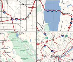
OpenStreetMap Americana is a public domain renderer being developed by members of the United States mapping community. The project began in May 2021 with a goal to eventually become part of the OpenStreetMap U.S. website, similar to regional renderers maintained by other OSMF local chapters in Europe and Asia. As of November 2022[update], it is currently in the early stages of development, with an initial focus on driving technical requirements in the underlying renderer and on the server side and cleanup efforts in the OpenStreetMap database.
Design
Americana applies cartographic practices that are characteristic of maps published in the United States. American publishers have developed a system of conventional symbols and line treatments that is distinct from – and often incompatible with – those used by their continental European counterparts.[1][2] However, most preexisting OpenStreetMap-based renderers have been designed according to European conventions, making OSM itself feel unfamiliar and counterintuitive to some mappers. Americana departs from other OSM renderers in favor of American conventions, demonstrating the versatility of the OSM data that underlies all these renderers.
As a starting point, Americana currently resembles a road atlas, as roads were some of the first features to be implemented. The style does not slavishly copy a particular map or map publisher; instead, it hews to a "typical" road atlas aesthetic. Whenever a new feature is introduced, contributors survey a number of print maps for inspiration. Although the project began with a focus on road features, it is not limited to motorized transportation. As the project begins to focus on higher zoom levels and a broader set of features, other design sources may become relevant, such as city tourist maps and topo maps. See this brainstorming document for more ideas that have been proposed for the project roadmap (no pun intended).
Features
Technically, Americana is not only a map style but also a Web application that displays the map. This application provides interactive map features that are infeasible in a conventional map style:
- Cities are labeled in both your preferred language and the local language, if the names differ. Set your preferred languages in the lower-right corner or by adjusting your browser preferences.
- A dynamic map legend gives you a visual overview of the various symbols, lines, and fills in this style, based on what is visible on the map in the current viewport.
As for the map style itself, it takes inspiration from multiple map genres. Features inspired by political maps:
- Places and points of interest use familiar symbology, such as a star on each state capital (capital=4).
- At low zoom levels, urbanized areas are highlighted in gold.
- Boundary lines are emphasized by a colored glow.
- Disputed boundaries (boundary=disputed) are distinct from mutually acknowledged boundaries.
- Coastlines (natural=coastline) are outlined except across the mouths of large rivers, and riverbanks and lake shores are also outlined at high zoom levels.
Features inspired by road atlases and road maps:
- Highways in over 60 countries[3] are marked by route shields instead of a one-size-fits-all symbol ("pancake text"). A wide variety of state, county, and township route shields accurately reflect the distinctions made by road signs while maintaining legibility at a small scale.
- Along a concurrency, each route shield is placed as a single unit but laid out along the path of the roadway. This is the preferred approach of cartographers and geographers.[4]
- Expressways (expressway=*) are given extra prominence regardless of road classification.
- Toll roads (toll=yes) receive a distinct color regardless of road classification.
- At lower zoom levels, streets are depicted as thin strokes corresponding to their centerlines, in contrast to the road casings found on European maps.[5]
- Unpaved roads are distinguished by an alternating fill, in contrast to European maps that use an alternating fill to represent railroad tracks.[1]
- Railroad tracks are distinguished by tick marks resembling railroad ties.[1]
Features inspired by city guides:
- Buildings are extruded to a fixed height for a faux isometric appearance (compare with tactile maps).
Americana's use of MapLibre and OpenMapTiles (through Planetiler) differentiates it from previous open-source renderers used by the U.S. community:
- Map data is rendered from vector tiles on the client side, resulting in seamless transitions as the user zooms in and out. Labels are automatically localized into your preferred language.
- Complex features are generalized at low zoom levels, for example by performing Ramer–Douglas–Peucker simplification.
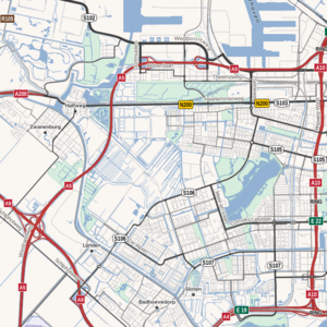
- Label placement is in general more highly optimized. For example, lake and reservoir labels are laid out along the curve of the main channel. This uptown area has more road label density than the comparatively blank openstreetmap-carto rendering, because roadways that had been frequently split due to turn lane tagging have been merged into longer linear features.
Technical details
Americana is implemented as a MapLibre style that loads OpenMapTiles vector tiles. Unlike most styles, this style is assembled on page load in JavaScript code using a mechanism called runtime styling.[6] Accompanying runtime styling code draws shield images on demand; this code is available as a separate library. The style is compatible with any OpenMapTiles-compliant tileset, including those generated by Planetiler.
The legend extracts currently visible features using a mechanism called feature querying. The name of each route network comes from Wikidata's items about highway systems.
How to contribute
If you are interested in contributing to these or other aspects of the renderer, please join the #americana-map-style channel in OSMUS Slack, or start a discussion on GitHub. Bug reports and pull requests are welcome, as are feature requests and insights about user expectations.
Deployments and derivatives
This wiki incorporates a "lite" version of the OSM Americana stylesheet that does not yet localize labels for technical reasons. The AARoads Wiki incorporates a fork of OSM Americana that recolors the style to serve as a locator map of the highway routes that that wiki documents. OSM by the Slice lets you draw a download area on an OSM Americana basemap. Go Map!! and MapComplete offer a shieldless "Americana" style as an optional background layer.
OSM Americana has been ported to a progressive Web application that you can install as a desktop or mobile application. [1]
GNOME Maps includes Americana shields in GNOME 46 and above. [2][3] You can also see these shields in maps.jwestman.net.
Overpass Ultra's default map style is powered by the OpenMapTiles-compatible vector tile server operated by the OSM Americana project.
OpenGeofiction Americana is a fork of the OSM Americana stylesheet based on OpenGeofiction data.
The automated Downticket Democrats account on Mastodon illustrates political fundraising messages with legislative district maps based on OSM Americana. [4]
See also
- Initial brainstorming
- TopOSM, another Americentric renderer
Notes and references
- ↑ 1.0 1.1 1.2 Monmonier, Mark (April 13, 2018). “How to Lie with Maps”. Chicago: University of Chicago Press. p. 141. ISBN 978-0-226-43608-1.
- ↑ Monmonier, Mark (July 27, 2015). “Mapping It Out: Expository Cartography for the Humanities and Social Sciences”. University of Chicago Press. p. 67. ISBN 978-0-226-21785-7.
- ↑ See OpenStreetMap Americana's custom shield coverage maps. For a complete list of supported network=* values, see OpenStreetMap Americana's project page on taginfo.
- ↑ Brewer, Cynthia A.; Guidero, Elaine M.; Fishburn, Kristin A.; Limpisathian, P. W.; Chittester, W. (October 16, 2015). “Planning for Automated Labeling of U.S. Routes with Multiple Shields and Names”. Annual Meeting of the North American Cartographic Information Society. Minneapolis.
- ↑ Strijk, Tycho (January 2001). “Geometric Algorithms for Cartographic Label Placement” (PDF). Utrecht University, Department of Computer Science. p. 161.
- ↑ Another map style built on runtime styling is the libshumate map style. The StyleJS specification formalizes this approach.
Further reading
- Nguyễn, Minh; Smalley, Clay (June 9, 2023). “The best of both worlds: designing an international American map”. State of the Map U.S. 2023. Richmond, Virginia: OpenStreetMap U.S.

- Smalley, Clay (August 19, 2022). “Route shields of the world in OpenStreetMap Americana”. State of the Map 2022. Florence: OpenStreetMap Foundation. [5]

- Smalley, Clay (January 24, 2025). “OpenStreetMap Americana: An OpenStreetMap U.S. Community Project”. Mapping USA 2025. OpenStreetMap U.S.

- Sperlongano, Brian (April 1, 2022). “An American Map Style”. State of the Map U.S. 2022. Tucson, Arizona: OpenStreetMap U.S.

- Sperlongano, Brian (May 17, 2023). “Building & Growing an Open Source Community”. Virtual Mappy Hours. OpenStreetMap U.S.

