TopOSM
 TopOSM | |
|---|---|
 TopOSM showing the hills east of Oakland and Berkeley, CA. | |
| Slippy map: | toposm |
| Style website: | Ahlzen/TopOSM GitHub |
TopOSM is an OpenStreetMap-based topographic map, similar in style to the USGS and National Geographic topographic maps and (to some degree) Google Maps in "Terrain" mode.
Note: map coverage is currently limited to the USA only.
The map features both contour lines and relief shading derived from data sources such as the USGS National Elevation Dataset, MassGIS and SRTM. Hydrographic features, such as lakes, rivers and wetlands, come from the USGS National Hydrographic Dataset and MassGIS. Roads, place names and all other map features are from the OpenStreetMap project.
NOTE: TopOSM maps are not updated as frequently as many other OSM based maps. Therefore, the map may not represent the latest data from the OpenStreetMap database. If you make a change in OpenStreetMap, it may take a significant period of time before it appears on toposm.com.
Coverage
TopOSM coverage is currently limited to the USA. Worldwide coverage is a long-term goal.
- Massachusetts
- Colorado
- West coast USA - WA, OR, CA, NV.
- Contiguous USA - In progress. More zoom levels are coming.
Features
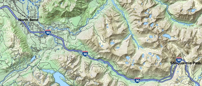
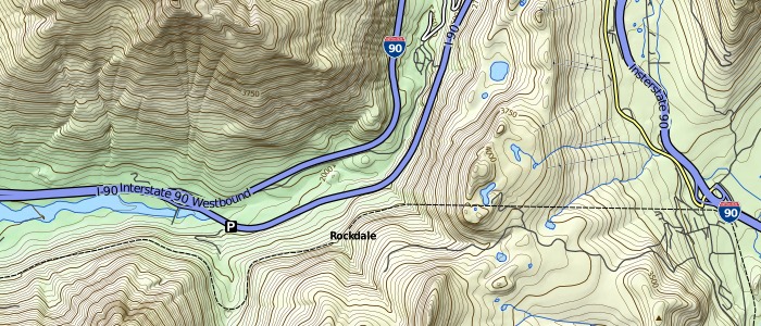
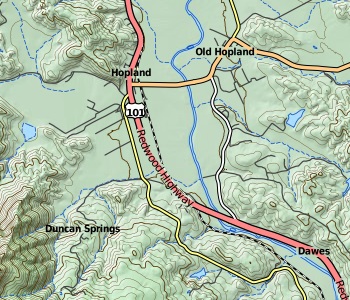
The primary goal of TopOSM is to create a high-quality, detailed, highly readable and aesthetically pleasing topographic map. Below are examples of some of the features of TopOSM maps.
Hillshading and contour lines
Hillshading and contour lines are derived from the 1/3 arc-second National Elevation Dataset from USGS. The hillshading layer is color-coded with a typical green/brown/white gradient by elevation. Additionally, on higher zoom levels, contour lines are available with 50 ft intervals with a major contour line every 250 ft. Contour lines are marked with elevation labels, in feet.
On recent TopOSM maps, the hillshading and contour line layers can be individually shown or hidden to customize the map.
Hydrography
The National Hydrographic Dataset from USGS provides very detailed hydrographic information, including rivers, perennial and intermittent streams and ditches, lakes and reservoirs, wetlands and glaciers, most of which are rendered on the map at higher zoom levels.
Map features
Most features on the map, such as cities, roads, buildings and railroads come from the OpenStreetMap project. As a consequence, the TopOSM map will constantly be improved and updated. Since the primary use for a topographic map are outdoors activities, special priority has been to include related features, such as hiking trails and features, bike paths, shelters, parks and nature reserves.
Road shields are customized for the United States, and a custom set of map symbols, inspired by the style commonly found on topographic maps, was created.
Labels
Similar to many printed maps, rather than having a solid outline, labels on TopOSM provide spacing between the text and other high-contrast features on the map, for easy reading without cluttering the map.
Map key
A (collapsible) map key is included with some TopOSM maps to aid interpretation.
Source code
All code, scripts and stylesheets, as well as (brief) instructions, required to set up your own TopOSM rendering server is on GitHub, at:
- Ahlzen/TopOSM GitHub
- Ahlzen/TopOSM2 GitHub
(an older version of the TopOSM code is available from the OSM SVN repository, at https://svn.openstreetmap.org/applications/rendering/toposm/)
Credits and licensing
TopOSM was created by User:Ahlzen, with contributions from several others, including Ian Dees, Nick Thompson and Phil Gold.
The author also wishes to thank the US Geological Survey and the State of Massachusetts for providing me with data for the project, and all OpenStreetMap contributors.
OpenStreetMap Data is available under the Open Data Commons Open Database (ODbL) license. NED and NHD data from USGS, being the work of a US goverment agency, is considered public domain. MassGIS data is free for any use, as long as proper attribution is given. Therefore, this topo map is available under the CC-BY-SA license as well.


