Organic Maps
| Organic Maps | ||||||||||||||||||||||||||||||||||||||||||||||||||||||||||||||||||||||||||||||||||||||||||||||||||||||||||||||||||||||||||||||||
|---|---|---|---|---|---|---|---|---|---|---|---|---|---|---|---|---|---|---|---|---|---|---|---|---|---|---|---|---|---|---|---|---|---|---|---|---|---|---|---|---|---|---|---|---|---|---|---|---|---|---|---|---|---|---|---|---|---|---|---|---|---|---|---|---|---|---|---|---|---|---|---|---|---|---|---|---|---|---|---|---|---|---|---|---|---|---|---|---|---|---|---|---|---|---|---|---|---|---|---|---|---|---|---|---|---|---|---|---|---|---|---|---|---|---|---|---|---|---|---|---|---|---|---|---|---|---|---|---|
| Author: | contributors list | |||||||||||||||||||||||||||||||||||||||||||||||||||||||||||||||||||||||||||||||||||||||||||||||||||||||||||||||||||||||||||||||
| License: | Apache License 2.0 (free of charge) | |||||||||||||||||||||||||||||||||||||||||||||||||||||||||||||||||||||||||||||||||||||||||||||||||||||||||||||||||||||||||||||||
| Platforms: | Android 5.0+, iOS 12.0+, iPadOS 12.0+, macOS 11.0+, visionOS 1.0+, and Linux | |||||||||||||||||||||||||||||||||||||||||||||||||||||||||||||||||||||||||||||||||||||||||||||||||||||||||||||||||||||||||||||||
| Status: | Active | |||||||||||||||||||||||||||||||||||||||||||||||||||||||||||||||||||||||||||||||||||||||||||||||||||||||||||||||||||||||||||||||
| Version: | 2025.01.26-9-android releases (2025-01-26) | |||||||||||||||||||||||||||||||||||||||||||||||||||||||||||||||||||||||||||||||||||||||||||||||||||||||||||||||||||||||||||||||
| Languages: | English, Arabic, Basque, Belarusian, Brazilian Portuguese, Bulgarian, Czech, Danish, Dutch, Finnish, French, German, Greek, Hungarian, Indonesian, Italian, Japanese, Korean, Latvian, Marathi, Norwegian Bokmål, Persian, Polish, Portuguese, Romanian, Russian, Serbian, Simplified Chinese, Slovak, Spanish, Swedish, Thai, Traditional Chinese, Turkish, Ukrainian, and Vietnamese
| |||||||||||||||||||||||||||||||||||||||||||||||||||||||||||||||||||||||||||||||||||||||||||||||||||||||||||||||||||||||||||||||
| Website: | organicmaps.app | |||||||||||||||||||||||||||||||||||||||||||||||||||||||||||||||||||||||||||||||||||||||||||||||||||||||||||||||||||||||||||||||
| Install: | ||||||||||||||||||||||||||||||||||||||||||||||||||||||||||||||||||||||||||||||||||||||||||||||||||||||||||||||||||||||||||||||||
| Source code: | organicmaps/organicmaps | |||||||||||||||||||||||||||||||||||||||||||||||||||||||||||||||||||||||||||||||||||||||||||||||||||||||||||||||||||||||||||||||
| Programming languages: | C++, Java, Objective-C, and Swift | |||||||||||||||||||||||||||||||||||||||||||||||||||||||||||||||||||||||||||||||||||||||||||||||||||||||||||||||||||||||||||||||
|
Privacy-focused, open-source, free and fast offline maps without ads. |
||||||||||||||||||||||||||||||||||||||||||||||||||||||||||||||||||||||||||||||||||||||||||||||||||||||||||||||||||||||||||||||||
| ||||||||||||||||||||||||||||||||||||||||||||||||||||||||||||||||||||||||||||||||||||||||||||||||||||||||||||||||||||||||||||||||
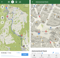
Organic Maps is an open source, community-developed map and satnav-style navigation app for walkers, drivers, and cyclists. The app offers worldwide offline maps based on OpenStreetMap data, and navigation with privacy - no location tracking, no data collection, and no ads. Most features operate without a data connection, ideal for travel on distant hiking trails or locations with poor connections. The app is free and is open-source software, with priority for community development and collaboration.[1]
Features
- Offline maps based on OpenStreetMap data
- Cycling routes, subway routes, hiking trails, and walking paths
- Contour lines, elevation profiles, peaks, and slopes
- Turn-by-turn walking, cycling, and car navigation with voice guidance
- Fast offline search on the map
- 3D buildings
- Opening hours
- Bookmarks
- Dark mode
- Editing points of interest in OpenStreetMap
Privacy policy
The app developers pledge to only request the bare minimum of permissions necessary[2] to deliver the offline maps, and to ensure:
- No ads
- No tracking
- No data collection
- No registration
- No spam emails
- No bloatware
Developer
Organic Maps was founded by Roman Tsisyk, and later joined by Alexander Borsuk and Viktor Govako. In 2011 MapsWithMe launched (later renamed Maps.Me), and was open-sourced in 2015. In 2021, the Maps.Me codebase was forked to create Organic Maps, focusing on privacy, performance and community.
Development support
- Since beginning by donations[3]
- By several institutional sponsors[4]
- Since Nov. 2023 by affiliate program ("KAYAK" button to hotels for meta search and room booking)[5]
Community
- Forgejo issue tracker
- Zulip
 @organicmaps@fosstodon.org
 @organicmaps@mastodon.social
 #organicmaps:matrix.org
- Telegram Group
- Telegram Group (French)
- Telegram Group (Russian)
External links
- Official Website
- Forgejo
- Organic Maps on FDroid
- Organic Maps on Google Play
- Organic Maps on Apple App Store
- BBBike.org extract service offers Organic Maps maps for an area of your choosing, weekly updates
References
- ↑ https://www.frandroid.com/android/applications/1023529_faites-connaissance-avec-organic-maps-un-google-maps-open-source
- ↑ Tsisyk, Roman (28 May 2021). “Comment on: mention that it is a maps.me fork in Readme”. organicmaps/organicmaps. GitHub. Archived from the original on 14 January 2025.
- ↑ https://organicmaps.app/donate
- ↑ https://git.omaps.dev/organicmaps/organicmaps#who-is-paying-for-the-development
- ↑ https://git.omaps.dev/organicmaps/organicmaps/releases/tag/2023.11.17-17-android

