OsmAPP
Jump to navigation
Jump to search
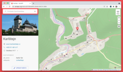
OsmAPP osmapp.org is a project aiming to create a universal OSM web app for the broad public. It should be as easy to use as Google Maps and offer editing capabilities like Maps.me or Osmand. Both on web and mobile.
| OsmAPP | ||||||||||||||||||||||||||||||||||||||||||||||||||||||||||||||||||||||||||||||||||||||||||||||||||
|---|---|---|---|---|---|---|---|---|---|---|---|---|---|---|---|---|---|---|---|---|---|---|---|---|---|---|---|---|---|---|---|---|---|---|---|---|---|---|---|---|---|---|---|---|---|---|---|---|---|---|---|---|---|---|---|---|---|---|---|---|---|---|---|---|---|---|---|---|---|---|---|---|---|---|---|---|---|---|---|---|---|---|---|---|---|---|---|---|---|---|---|---|---|---|---|---|---|---|
| License: | GNU GPL v3 (free of charge) | |||||||||||||||||||||||||||||||||||||||||||||||||||||||||||||||||||||||||||||||||||||||||||||||||
| Platform: | Web | |||||||||||||||||||||||||||||||||||||||||||||||||||||||||||||||||||||||||||||||||||||||||||||||||
| Status: | Active | |||||||||||||||||||||||||||||||||||||||||||||||||||||||||||||||||||||||||||||||||||||||||||||||||
| Languages: | ||||||||||||||||||||||||||||||||||||||||||||||||||||||||||||||||||||||||||||||||||||||||||||||||||
| Website: | https://osmapp.org/ | |||||||||||||||||||||||||||||||||||||||||||||||||||||||||||||||||||||||||||||||||||||||||||||||||
| Source code: | https://github.com/zbycz/osmapp | |||||||||||||||||||||||||||||||||||||||||||||||||||||||||||||||||||||||||||||||||||||||||||||||||
| Programming language: | TypeScript | |||||||||||||||||||||||||||||||||||||||||||||||||||||||||||||||||||||||||||||||||||||||||||||||||
|
A universal app for OpenStreetMap for everyday use. |
||||||||||||||||||||||||||||||||||||||||||||||||||||||||||||||||||||||||||||||||||||||||||||||||||
| ||||||||||||||||||||||||||||||||||||||||||||||||||||||||||||||||||||||||||||||||||||||||||||||||||
Features:
- clickable map – poi, cities, localities, ponds (more coming soon)
- feature panel – presets and fields from iD editor
- Display multiple images from Wikipedia, Wikidata, Commons, Mapillary or Fody
- Line numbers on public transport stops
- Runway table on airports
- editing – Save changes with osm login. Insert Notes for anonymous users.
- Opening hours editor – use simple editor for most common cases.
- search engine – try for example "Tesco, London" (powered by Photon).
- Category search from iD editor presets
- For advanced users: support for Overpass queries (eg.
amenity=*orop:<query>)
- vector maps – with the possibility of tilting to 3D (drag the compass, or do two fingers drag)
- 3D terrain – turned on when tilted
- tourist map – vector Outoodr map from MapTiler including marked routes
- layer switcher – still basic, but you can add your own layers
- mobile applications – using PWA technology, see osmapp.org/install
- permanent URLs – eg. osmapp.org/way/123557148 and shortener, eg. osmapp.org/kkjwwaw
- creating POIs – after clicking the coordinates (see eg. osmapp.org/50.1,14.39)
- languages – interface in English, Czech, German, Polish, Spanish, Amharic, Italian, French
- undelete – undo accidental delete in osmapp or elsewhere, eg. here
- and lot of little details
